You are here: Home > Network List > N4 - Central and EAstern US Network Stations List
> Station N51A Ashland, OH, USA > Earthquake Result Viewer
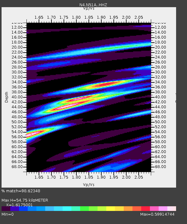
N51A Ashland, OH, USA - Earthquake Result Viewer
| Earthquake location: |
Near Coast Of Central Chile |
| Earthquake latitude/longitude: |
-31.6/-71.8 |
| Earthquake time(UTC): |
2015/09/16 (259) 22:54:31 GMT |
| Earthquake Depth: |
12 km |
| Earthquake Magnitude: |
8.3 MWW, 7.9 MI |
| Earthquake Catalog/Contributor: |
NEIC PDE/NEIC COMCAT |
|
| Network: |
N4 Central and EAstern US Network |
| Station: |
N51A Ashland, OH, USA |
| Lat/Lon: |
40.92 N/82.37 W |
| Elevation: |
343 m |
|
| Distance: |
72.8 deg |
| Az: |
351.591 deg |
| Baz: |
170.521 deg |
| Ray Param: |
0.053415395 |
| Estimated Moho Depth: |
54.75 km |
| Estimated Crust Vp/Vs: |
1.62 |
| Assumed Crust Vp: |
6.498 km/s |
| Estimated Crust Vs: |
4.017 km/s |
| Estimated Crust Poisson's Ratio: |
0.19 |
|
| Radial Match: |
98.62348 % |
| Radial Bump: |
254 |
| Transverse Match: |
92.43278 % |
| Transverse Bump: |
400 |
| SOD ConfigId: |
7422571 |
| Insert Time: |
2019-04-20 19:02:13.906 +0000 |
| GWidth: |
2.5 |
| Max Bumps: |
400 |
| Tol: |
0.001 |
|

Signal To Noise
| Channel | StoN | STA | LTA |
| N4:N51A: :HHZ:20150916T23:05:28.349998Z | 12.193126 | 2.7139902E-6 | 2.2258364E-7 |
| N4:N51A: :HHN:20150916T23:05:28.349998Z | 6.8312244 | 1.3030201E-6 | 1.9074474E-7 |
| N4:N51A: :HHE:20150916T23:05:28.349998Z | 2.980265 | 6.995054E-7 | 2.347125E-7 |
| Arrivals |
| Ps | 5.4 SECOND |
| PpPs | 21 SECOND |
| PsPs/PpSs | 27 SECOND |


