You are here: Home > Network List > N4 - Central and EAstern US Network Stations List
> Station T60A Surry, VA, USA > Earthquake Result Viewer
T60A Surry, VA, USA - Earthquake Result Viewer
| Earthquake location: |
Near Coast Of Central Chile |
| Earthquake latitude/longitude: |
-31.6/-71.8 |
| Earthquake time(UTC): |
2015/09/16 (259) 22:54:31 GMT |
| Earthquake Depth: |
12 km |
| Earthquake Magnitude: |
8.3 MWW, 7.9 MI |
| Earthquake Catalog/Contributor: |
NEIC PDE/NEIC COMCAT |
|
| Network: |
N4 Central and EAstern US Network |
| Station: |
T60A Surry, VA, USA |
| Lat/Lon: |
37.14 N/76.73 W |
| Elevation: |
11 m |
|
| Distance: |
68.5 deg |
| Az: |
355.722 deg |
| Baz: |
175.431 deg |
| Ray Param: |
0.056242865 |
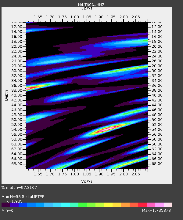
| Estimated Moho Depth: |
53.5 km |
| Estimated Crust Vp/Vs: |
1.93 |
| Assumed Crust Vp: |
6.565 km/s |
| Estimated Crust Vs: |
3.393 km/s |
| Estimated Crust Poisson's Ratio: |
0.32 |
|
| Radial Match: |
97.3107 % |
| Radial Bump: |
400 |
| Transverse Match: |
89.89132 % |
| Transverse Bump: |
400 |
| SOD ConfigId: |
7422571 |
| Insert Time: |
2019-04-20 19:02:43.631 +0000 |
| GWidth: |
2.5 |
| Max Bumps: |
400 |
| Tol: |
0.001 |
|

Signal To Noise
| Channel | StoN | STA | LTA |
| N4:T60A: :HHZ:20150916T23:05:02.320029Z | 11.953632 | 3.324184E-6 | 2.7808986E-7 |
| N4:T60A: :HHN:20150916T23:05:02.320029Z | 6.688984 | 2.616104E-6 | 3.911063E-7 |
| N4:T60A: :HHE:20150916T23:05:02.320029Z | 0.9586327 | 3.4775564E-7 | 3.6276214E-7 |
| Arrivals |
| Ps | 7.9 SECOND |
| PpPs | 23 SECOND |
| PsPs/PpSs | 31 SECOND |


