You are here: Home > Network List > N4 - Central and EAstern US Network Stations List
> Station U59A Littleton, NC, USA > Earthquake Result Viewer
U59A Littleton, NC, USA - Earthquake Result Viewer
| Earthquake location: |
Near Coast Of Central Chile |
| Earthquake latitude/longitude: |
-31.6/-71.8 |
| Earthquake time(UTC): |
2015/09/16 (259) 22:54:31 GMT |
| Earthquake Depth: |
12 km |
| Earthquake Magnitude: |
8.3 MWW, 7.9 MI |
| Earthquake Catalog/Contributor: |
NEIC PDE/NEIC COMCAT |
|
| Network: |
N4 Central and EAstern US Network |
| Station: |
U59A Littleton, NC, USA |
| Lat/Lon: |
36.35 N/77.79 W |
| Elevation: |
99 m |
|
| Distance: |
67.8 deg |
| Az: |
354.736 deg |
| Baz: |
174.434 deg |
| Ray Param: |
0.05670496 |
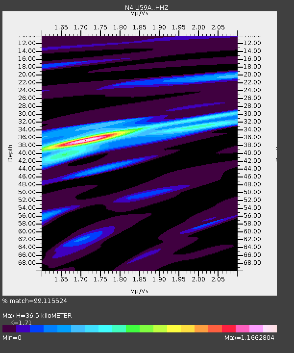
| Estimated Moho Depth: |
36.5 km |
| Estimated Crust Vp/Vs: |
1.71 |
| Assumed Crust Vp: |
6.565 km/s |
| Estimated Crust Vs: |
3.839 km/s |
| Estimated Crust Poisson's Ratio: |
0.24 |
|
| Radial Match: |
99.115524 % |
| Radial Bump: |
170 |
| Transverse Match: |
95.284065 % |
| Transverse Bump: |
355 |
| SOD ConfigId: |
7422571 |
| Insert Time: |
2019-04-20 19:02:49.108 +0000 |
| GWidth: |
2.5 |
| Max Bumps: |
400 |
| Tol: |
0.001 |
|

Signal To Noise
| Channel | StoN | STA | LTA |
| N4:U59A: :HHZ:20150916T23:04:57.899985Z | 14.646013 | 2.915423E-6 | 1.9905914E-7 |
| N4:U59A: :HHN:20150916T23:04:57.899985Z | 6.2740283 | 1.3666606E-6 | 2.1782824E-7 |
| N4:U59A: :HHE:20150916T23:04:57.899985Z | 1.7338827 | 3.2525753E-7 | 1.8758914E-7 |
| Arrivals |
| Ps | 4.1 SECOND |
| PpPs | 14 SECOND |
| PsPs/PpSs | 19 SECOND |


