You are here: Home > Network List > ON - RSIS-Rede Sismografica do Sul e Sudeste Observatorio Nacional, Brazil Stations List
> Station GUA01 "OBSN: [GUA01] Guaratinga, BA" > Earthquake Result Viewer
GUA01 "OBSN: [GUA01] Guaratinga, BA" - Earthquake Result Viewer
| Earthquake location: |
Near Coast Of Central Chile |
| Earthquake latitude/longitude: |
-31.6/-71.8 |
| Earthquake time(UTC): |
2015/09/16 (259) 22:54:31 GMT |
| Earthquake Depth: |
12 km |
| Earthquake Magnitude: |
8.3 MWW, 7.9 MI |
| Earthquake Catalog/Contributor: |
NEIC PDE/NEIC COMCAT |
|
| Network: |
ON RSIS-Rede Sismografica do Sul e Sudeste Observatorio Nacional, Brazil |
| Station: |
GUA01 "OBSN: [GUA01] Guaratinga, BA" |
| Lat/Lon: |
16.58 S/39.81 W |
| Elevation: |
198 m |
|
| Distance: |
32.6 deg |
| Az: |
70.27 deg |
| Baz: |
236.905 deg |
| Ray Param: |
0.07857017 |
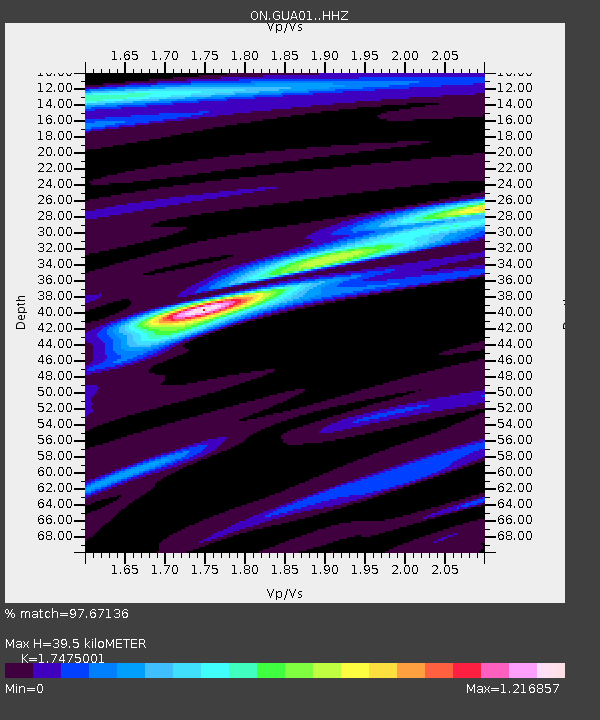
| Estimated Moho Depth: |
39.5 km |
| Estimated Crust Vp/Vs: |
1.75 |
| Assumed Crust Vp: |
6.391 km/s |
| Estimated Crust Vs: |
3.657 km/s |
| Estimated Crust Poisson's Ratio: |
0.26 |
|
| Radial Match: |
97.67136 % |
| Radial Bump: |
226 |
| Transverse Match: |
91.60435 % |
| Transverse Bump: |
400 |
| SOD ConfigId: |
7422571 |
| Insert Time: |
2019-04-20 19:04:15.149 +0000 |
| GWidth: |
2.5 |
| Max Bumps: |
400 |
| Tol: |
0.001 |
|

Signal To Noise
| Channel | StoN | STA | LTA |
| ON:GUA01: :HHZ:20150916T23:00:31.648002Z | 9.130231 | 3.4602608E-6 | 3.7898943E-7 |
| ON:GUA01: :HHN:20150916T23:00:31.648002Z | 5.591771 | 1.1964252E-6 | 2.1396174E-7 |
| ON:GUA01: :HHE:20150916T23:00:31.648002Z | 6.979576 | 1.7192399E-6 | 2.463244E-7 |
| Arrivals |
| Ps | 5.0 SECOND |
| PpPs | 16 SECOND |
| PsPs/PpSs | 21 SECOND |


