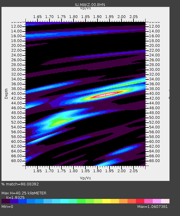
MAKZ Makanchi, Kazakhstan - Earthquake Result Viewer
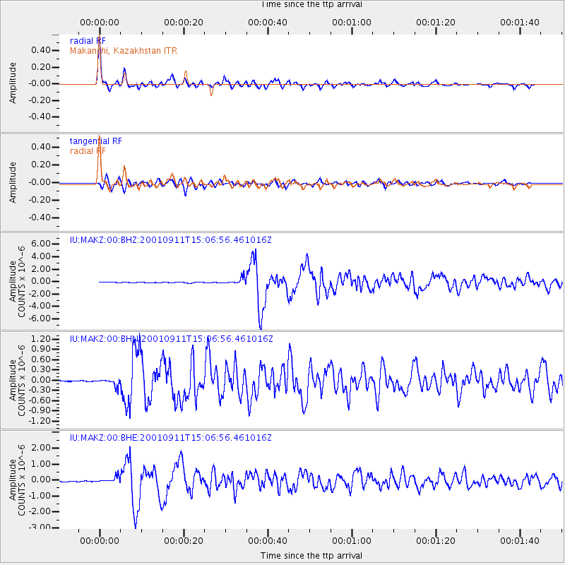
Earthquake location: Irian Jaya Region, Indonesia
Earthquake latitude/longitude: -0.6/133.1
Earthquake time(UTC): 2001/09/11 (254) 14:56:50 GMT
Earthquake Depth: 33 km
Earthquake Magnitude: 5.8 MB, 6.4 MS, 6.6 MW, 6.5 MW
Earthquake Catalog/Contributor: WHDF/NEIC
Network: IU Global Seismograph Network (GSN - IRIS/USGS)
Station: MAKZ Makanchi, Kazakhstan
Lat/Lon: 46.81 N/81.98 E
Elevation: 600 m
Distance: 64.9 deg
Az: 323.804 deg
Baz: 120.717 deg
Ray Param: 0.0585445
Estimated Moho Depth: 40.25 km
Estimated Crust Vp/Vs: 1.93
Assumed Crust Vp: 6.571 km/s
Estimated Crust Vs: 3.4 km/s
Estimated Crust Poisson's Ratio: 0.32
Radial Match: 98.08392 %
Radial Bump: 351
Transverse Match: 92.74768 %
Transverse Bump: 400
SOD ConfigId: 20082
Insert Time: 2010-03-04 19:36:31.204 +0000
GWidth: 2.5
Max Bumps: 400
Tol: 0.001

Signal To Noise

ChannelStoNSTALTA
IU:MAKZ:00:BHN:20010911T15:06:56.461016Z3.67762831.0154138E-72.7610561E-8
IU:MAKZ:00:BHE:20010911T15:06:56.461016Z4.76008371.9035348E-73.9989523E-8
IU:MAKZ:00:BHZ:20010911T15:06:56.461016Z11.8220345.281192E-74.467245E-8
Arrivals
Ps5.9 SECOND
PpPs17 SECOND
PsPs/PpSs23 SECOND