You are here: Home > Network List > RV - Regional Alberta Seismic Observatory for Earthquake Studies Network Stations List
> Station MANA Manning, AB > Earthquake Result Viewer
MANA Manning, AB - Earthquake Result Viewer
| Earthquake location: |
Near Coast Of Central Chile |
| Earthquake latitude/longitude: |
-31.6/-71.8 |
| Earthquake time(UTC): |
2015/09/16 (259) 22:54:31 GMT |
| Earthquake Depth: |
12 km |
| Earthquake Magnitude: |
8.3 MWW, 7.9 MI |
| Earthquake Catalog/Contributor: |
NEIC PDE/NEIC COMCAT |
|
| Network: |
RV Regional Alberta Seismic Observatory for Earthquake Studies Network |
| Station: |
MANA Manning, AB |
| Lat/Lon: |
56.86 N/117.64 W |
| Elevation: |
480 m |
|
| Distance: |
96.3 deg |
| Az: |
336.624 deg |
| Baz: |
141.945 deg |
| Ray Param: |
0.040561248 |
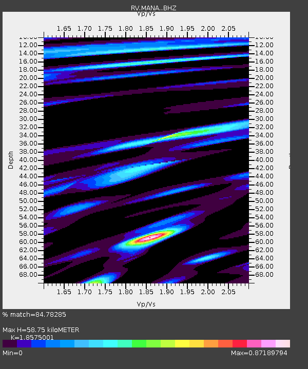
| Estimated Moho Depth: |
58.75 km |
| Estimated Crust Vp/Vs: |
1.86 |
| Assumed Crust Vp: |
6.444 km/s |
| Estimated Crust Vs: |
3.469 km/s |
| Estimated Crust Poisson's Ratio: |
0.30 |
|
| Radial Match: |
84.78285 % |
| Radial Bump: |
400 |
| Transverse Match: |
50.836605 % |
| Transverse Bump: |
400 |
| SOD ConfigId: |
7422571 |
| Insert Time: |
2019-04-20 19:05:20.860 +0000 |
| GWidth: |
2.5 |
| Max Bumps: |
400 |
| Tol: |
0.001 |
|

Signal To Noise
| Channel | StoN | STA | LTA |
| RV:MANA: :BHZ:20150916T23:07:27.76998Z | 1.9366773 | 6.2933907E-7 | 3.2495814E-7 |
| RV:MANA: :BHN:20150916T23:07:27.76998Z | 0.9602236 | 1.8977076E-6 | 1.9763183E-6 |
| RV:MANA: :BHE:20150916T23:07:27.76998Z | 0.55643266 | 2.143142E-6 | 3.8515745E-6 |
| Arrivals |
| Ps | 8.0 SECOND |
| PpPs | 26 SECOND |
| PsPs/PpSs | 34 SECOND |


