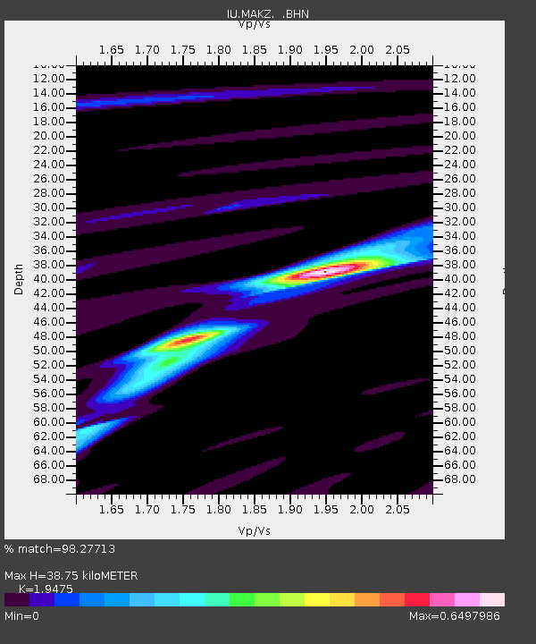
MAKZ Makanchi, Kazakhstan - Earthquake Result Viewer
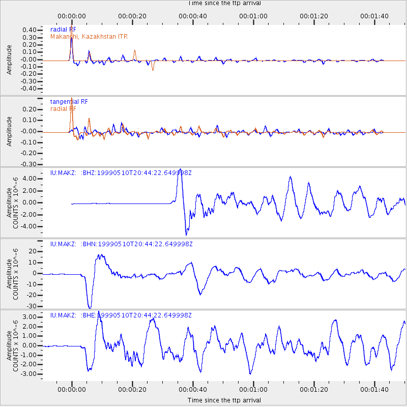
Earthquake location: New Britain Region, P.N.G.
Earthquake latitude/longitude: -5.2/150.9
Earthquake time(UTC): 1999/05/10 (130) 20:33:02 GMT
Earthquake Depth: 138 km
Earthquake Magnitude: 6.5 MB, 6.8 MS, 7.1 MW, 6.5 MB
Earthquake Catalog/Contributor: WHDF/NEIC
Network: IU Global Seismograph Network (GSN - IRIS/USGS)
Station: MAKZ Makanchi, Kazakhstan
Lat/Lon: 46.81 N/81.98 E
Elevation: 600 m
Distance: 79.6 deg
Az: 319.334 deg
Baz: 109.107 deg
Ray Param: 0.048555788
Estimated Moho Depth: 38.75 km
Estimated Crust Vp/Vs: 1.95
Assumed Crust Vp: 6.571 km/s
Estimated Crust Vs: 3.374 km/s
Estimated Crust Poisson's Ratio: 0.32
Radial Match: 98.27713 %
Radial Bump: 290
Transverse Match: 94.3457 %
Transverse Bump: 399
SOD ConfigId: 4480
Insert Time: 2010-03-04 19:36:45.814 +0000
GWidth: 2.5
Max Bumps: 400
Tol: 0.001

Signal To Noise

ChannelStoNSTALTA
IU:MAKZ: :BHN:19990510T20:44:22.649998Z19.8864152.7768206E-61.3963404E-7
IU:MAKZ: :BHE:19990510T20:44:22.649998Z8.8896952.768426E-73.114197E-8
IU:MAKZ: :BHZ:19990510T20:44:22.649998Z25.4915736.5575296E-72.5724304E-8
Arrivals
Ps5.7 SECOND
PpPs17 SECOND
PsPs/PpSs23 SECOND