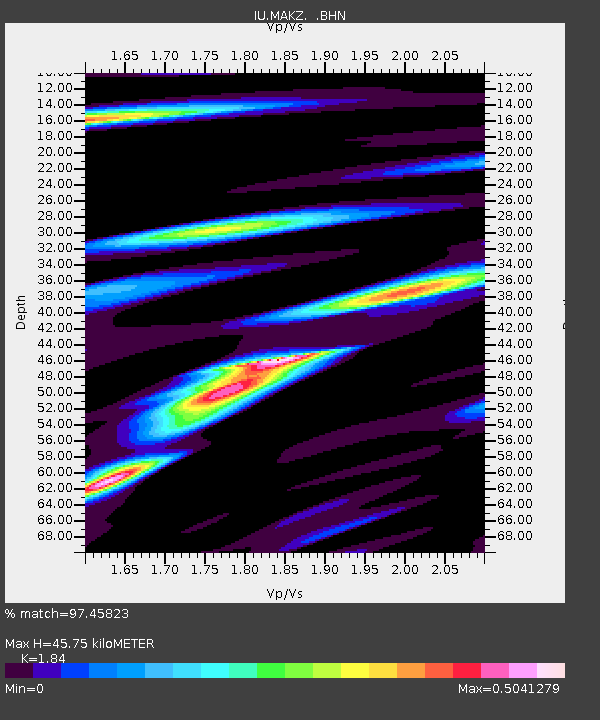
MAKZ Makanchi, Kazakhstan - Earthquake Result Viewer
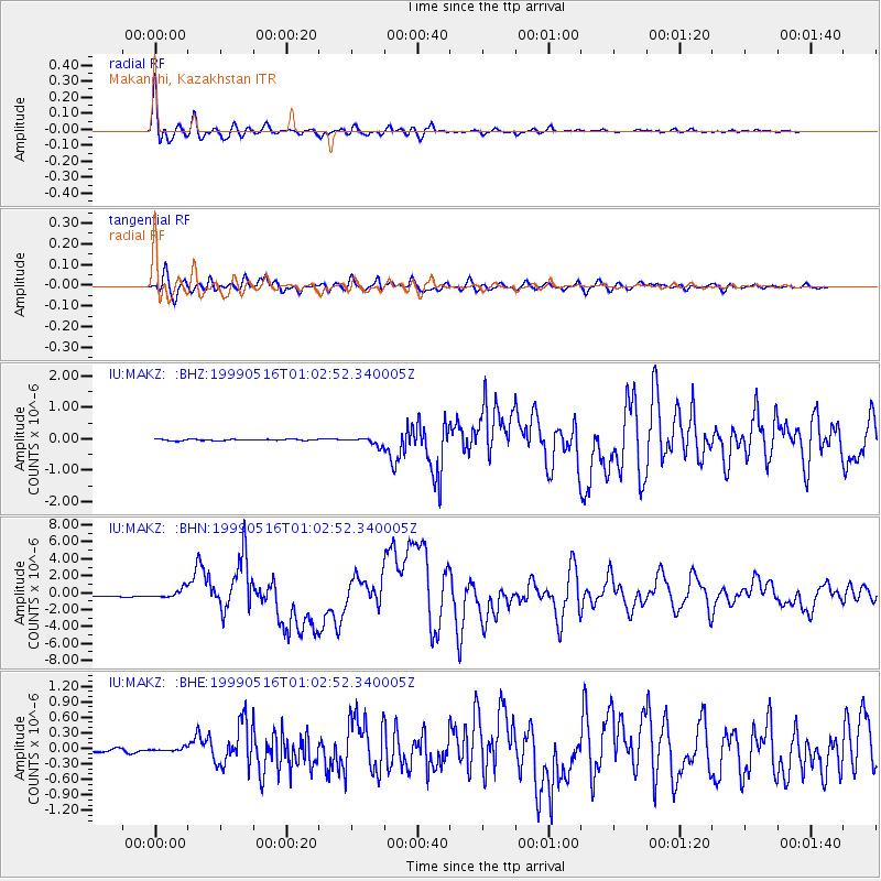
Earthquake location: New Britain Region, P.N.G.
Earthquake latitude/longitude: -4.8/152.5
Earthquake time(UTC): 1999/05/16 (136) 00:51:20 GMT
Earthquake Depth: 74 km
Earthquake Magnitude: 6.0 MB, 7.0 MS, 7.1 MW, 6.3 ME
Earthquake Catalog/Contributor: WHDF/NEIC
Network: IU Global Seismograph Network (GSN - IRIS/USGS)
Station: MAKZ Makanchi, Kazakhstan
Lat/Lon: 46.81 N/81.98 E
Elevation: 600 m
Distance: 80.3 deg
Az: 318.934 deg
Baz: 107.609 deg
Ray Param: 0.048224926
Estimated Moho Depth: 45.75 km
Estimated Crust Vp/Vs: 1.84
Assumed Crust Vp: 6.571 km/s
Estimated Crust Vs: 3.571 km/s
Estimated Crust Poisson's Ratio: 0.29
Radial Match: 97.45823 %
Radial Bump: 400
Transverse Match: 91.3839 %
Transverse Bump: 400
SOD ConfigId: 4480
Insert Time: 2010-03-04 19:36:48.281 +0000
GWidth: 2.5
Max Bumps: 400
Tol: 0.001

Signal To Noise

ChannelStoNSTALTA
IU:MAKZ: :BHN:19990516T01:02:52.340005Z6.32593775.297068E-78.37357E-8
IU:MAKZ: :BHE:19990516T01:02:52.340005Z1.06394353.147338E-82.9581813E-8
IU:MAKZ: :BHZ:19990516T01:02:52.340005Z5.30895761.2197297E-72.2974938E-8
Arrivals
Ps6.0 SECOND
PpPs19 SECOND
PsPs/PpSs25 SECOND