You are here: Home > Network List > IU - Global Seismograph Network (GSN - IRIS/USGS) Stations List
> Station MAKZ Makanchi, Kazakhstan > Earthquake Result Viewer
MAKZ Makanchi, Kazakhstan - Earthquake Result Viewer
| Earthquake location: |
Irian Jaya, Indonesia |
| Earthquake latitude/longitude: |
-2.6/138.2 |
| Earthquake time(UTC): |
1999/05/16 (136) 15:25:53 GMT |
| Earthquake Depth: |
59 km |
| Earthquake Magnitude: |
6.1 MB, 6.2 MS, 6.4 MW, 6.4 ME |
| Earthquake Catalog/Contributor: |
WHDF/NEIC |
|
| Network: |
IU Global Seismograph Network (GSN - IRIS/USGS) |
| Station: |
MAKZ Makanchi, Kazakhstan |
| Lat/Lon: |
46.81 N/81.98 E |
| Elevation: |
600 m |
|
| Distance: |
69.6 deg |
| Az: |
322.473 deg |
| Baz: |
117.639 deg |
| Ray Param: |
0.05538883 |
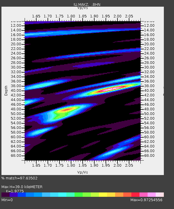
| Estimated Moho Depth: |
39.0 km |
| Estimated Crust Vp/Vs: |
1.98 |
| Assumed Crust Vp: |
6.571 km/s |
| Estimated Crust Vs: |
3.323 km/s |
| Estimated Crust Poisson's Ratio: |
0.33 |
|
| Radial Match: |
97.63502 % |
| Radial Bump: |
400 |
| Transverse Match: |
92.26034 % |
| Transverse Bump: |
400 |
| SOD ConfigId: |
4480 |
| Insert Time: |
2010-03-04 19:36:50.294 +0000 |
| GWidth: |
2.5 |
| Max Bumps: |
400 |
| Tol: |
0.001 |
|

Signal To Noise
| Channel | StoN | STA | LTA |
| IU:MAKZ: :BHN:19990516T15:36:26.054019Z | 102.2627 | 5.24402E-6 | 5.1279887E-8 |
| IU:MAKZ: :BHE:19990516T15:36:26.054019Z | 26.126192 | 9.4817653E-7 | 3.629218E-8 |
| IU:MAKZ: :BHZ:19990516T15:36:26.054019Z | 95.30641 | 1.3204027E-6 | 1.385429E-8 |
| Arrivals |
| Ps | 6.0 SECOND |
| PpPs | 17 SECOND |
| PsPs/PpSs | 23 SECOND |


