You are here: Home > Network List > TA - USArray Transportable Network (new EarthScope stations) Stations List
> Station L04D Klamath Falls, OR, USA > Earthquake Result Viewer
L04D Klamath Falls, OR, USA - Earthquake Result Viewer
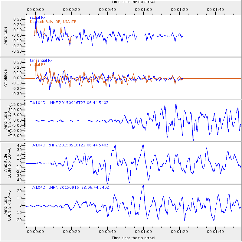
| Earthquake location: |
Near Coast Of Central Chile |
| Earthquake latitude/longitude: |
-31.6/-71.8 |
| Earthquake time(UTC): |
2015/09/16 (259) 22:54:31 GMT |
| Earthquake Depth: |
12 km |
| Earthquake Magnitude: |
8.3 MWW, 7.9 MI |
| Earthquake Catalog/Contributor: |
NEIC PDE/NEIC COMCAT |
|
| Network: |
TA USArray Transportable Network (new EarthScope stations) |
| Station: |
L04D Klamath Falls, OR, USA |
| Lat/Lon: |
42.22 N/122.30 W |
| Elevation: |
1437 m |
|
| Distance: |
86.9 deg |
| Az: |
324.938 deg |
| Baz: |
138.699 deg |
| Ray Param: |
0.043703087 |
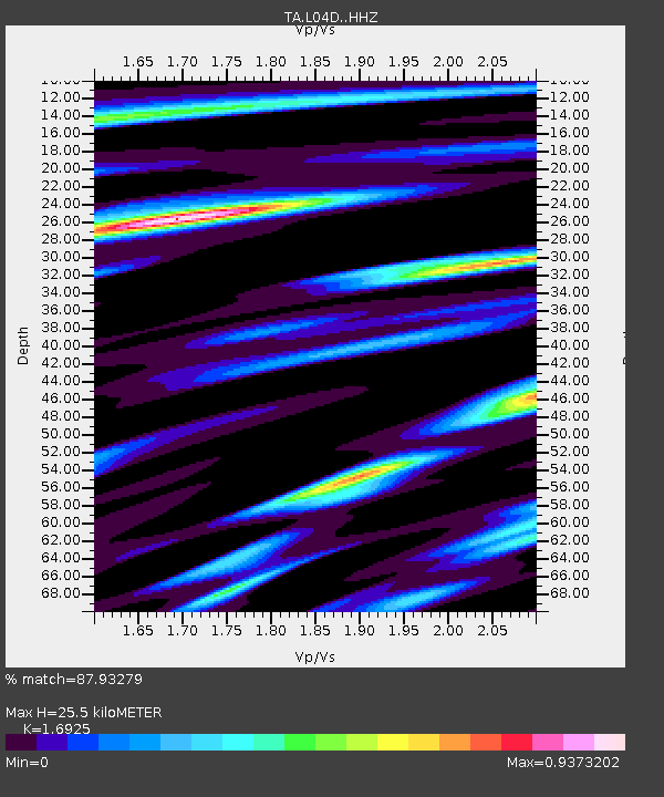
| Estimated Moho Depth: |
25.5 km |
| Estimated Crust Vp/Vs: |
1.69 |
| Assumed Crust Vp: |
6.522 km/s |
| Estimated Crust Vs: |
3.853 km/s |
| Estimated Crust Poisson's Ratio: |
0.23 |
|
| Radial Match: |
87.93279 % |
| Radial Bump: |
400 |
| Transverse Match: |
84.91311 % |
| Transverse Bump: |
400 |
| SOD ConfigId: |
7422571 |
| Insert Time: |
2019-04-20 19:05:58.145 +0000 |
| GWidth: |
2.5 |
| Max Bumps: |
400 |
| Tol: |
0.001 |
|
Signal To Noise
| Channel | StoN | STA | LTA |
| TA:L04D: :HHZ:20150916T23:06:44.540Z | 4.003934 | 1.4940119E-6 | 3.73136E-7 |
| TA:L04D: :HHN:20150916T23:06:44.540Z | 1.508157 | 6.2824165E-7 | 4.165625E-7 |
| TA:L04D: :HHE:20150916T23:06:44.540Z | 0.9269019 | 3.2347438E-7 | 3.4898449E-7 |
| Arrivals |
| Ps | 2.8 SECOND |
| PpPs | 10 SECOND |
| PsPs/PpSs | 13 SECOND |


