You are here: Home > Network List > TA - USArray Transportable Network (new EarthScope stations) Stations List
> Station O48A Farmland, IN, USA > Earthquake Result Viewer
O48A Farmland, IN, USA - Earthquake Result Viewer
| Earthquake location: |
Near Coast Of Central Chile |
| Earthquake latitude/longitude: |
-31.6/-71.8 |
| Earthquake time(UTC): |
2015/09/16 (259) 22:54:31 GMT |
| Earthquake Depth: |
12 km |
| Earthquake Magnitude: |
8.3 MWW, 7.9 MI |
| Earthquake Catalog/Contributor: |
NEIC PDE/NEIC COMCAT |
|
| Network: |
TA USArray Transportable Network (new EarthScope stations) |
| Station: |
O48A Farmland, IN, USA |
| Lat/Lon: |
40.26 N/85.16 W |
| Elevation: |
300 m |
|
| Distance: |
72.5 deg |
| Az: |
349.283 deg |
| Baz: |
168.031 deg |
| Ray Param: |
0.053582367 |
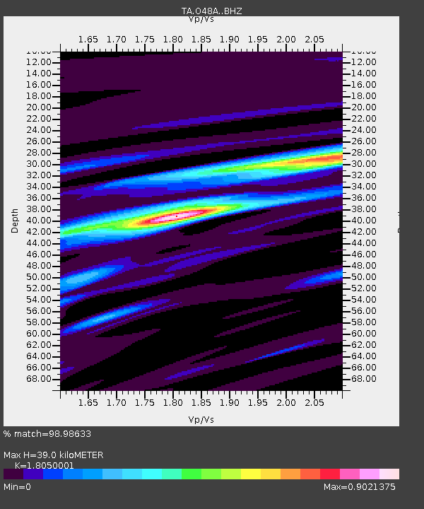
| Estimated Moho Depth: |
39.0 km |
| Estimated Crust Vp/Vs: |
1.81 |
| Assumed Crust Vp: |
6.498 km/s |
| Estimated Crust Vs: |
3.6 km/s |
| Estimated Crust Poisson's Ratio: |
0.28 |
|
| Radial Match: |
98.98633 % |
| Radial Bump: |
186 |
| Transverse Match: |
97.01401 % |
| Transverse Bump: |
367 |
| SOD ConfigId: |
7422571 |
| Insert Time: |
2019-04-20 19:06:13.139 +0000 |
| GWidth: |
2.5 |
| Max Bumps: |
400 |
| Tol: |
0.001 |
|
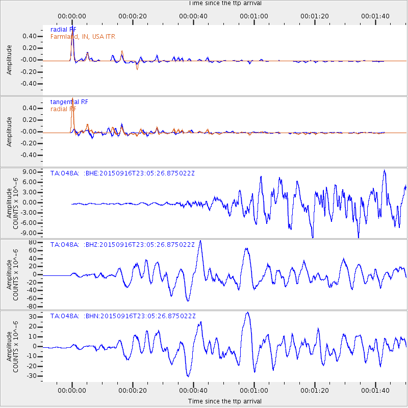
Signal To Noise
| Channel | StoN | STA | LTA |
| TA:O48A: :BHZ:20150916T23:05:26.875022Z | 15.110458 | 3.2215933E-6 | 2.1320288E-7 |
| TA:O48A: :BHN:20150916T23:05:26.875022Z | 6.203066 | 1.5080088E-6 | 2.4310702E-7 |
| TA:O48A: :BHE:20150916T23:05:26.875022Z | 1.7528074 | 2.4693688E-7 | 1.4088079E-7 |
| Arrivals |
| Ps | 5.0 SECOND |
| PpPs | 16 SECOND |
| PsPs/PpSs | 21 SECOND |


