You are here: Home > Network List > IU - Global Seismograph Network (GSN - IRIS/USGS) Stations List
> Station MAKZ Makanchi, Kazakhstan > Earthquake Result Viewer
MAKZ Makanchi, Kazakhstan - Earthquake Result Viewer
| Earthquake location: |
Arabian Sea |
| Earthquake latitude/longitude: |
14.7/55.8 |
| Earthquake time(UTC): |
2002/08/13 (225) 08:37:22 GMT |
| Earthquake Depth: |
10 km |
| Earthquake Magnitude: |
5.8 MB, 5.5 MS, 5.8 MW, 5.6 MW |
| Earthquake Catalog/Contributor: |
WHDF/NEIC |
|
| Network: |
IU Global Seismograph Network (GSN - IRIS/USGS) |
| Station: |
MAKZ Makanchi, Kazakhstan |
| Lat/Lon: |
46.81 N/81.98 E |
| Elevation: |
600 m |
|
| Distance: |
38.7 deg |
| Az: |
28.937 deg |
| Baz: |
222.96 deg |
| Ray Param: |
0.075414345 |
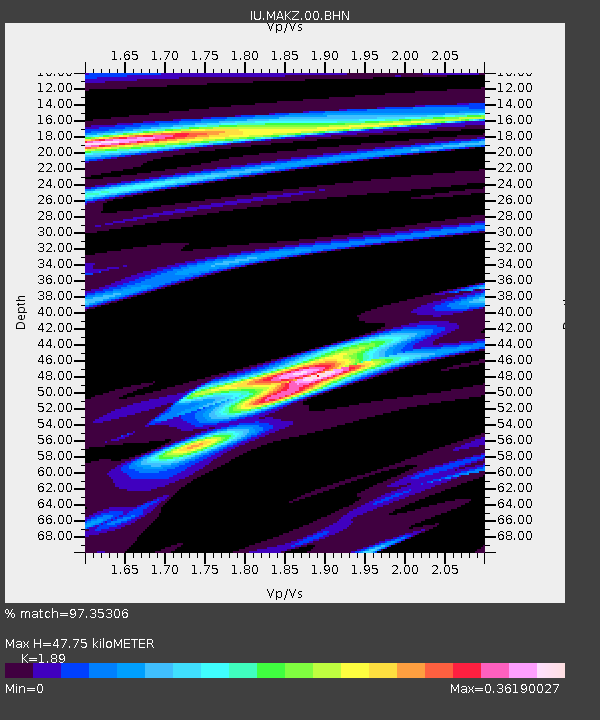
| Estimated Moho Depth: |
47.75 km |
| Estimated Crust Vp/Vs: |
1.89 |
| Assumed Crust Vp: |
6.571 km/s |
| Estimated Crust Vs: |
3.477 km/s |
| Estimated Crust Poisson's Ratio: |
0.31 |
|
| Radial Match: |
97.35306 % |
| Radial Bump: |
164 |
| Transverse Match: |
83.52783 % |
| Transverse Bump: |
400 |
| SOD ConfigId: |
20082 |
| Insert Time: |
2010-03-04 19:37:04.946 +0000 |
| GWidth: |
2.5 |
| Max Bumps: |
400 |
| Tol: |
0.001 |
|
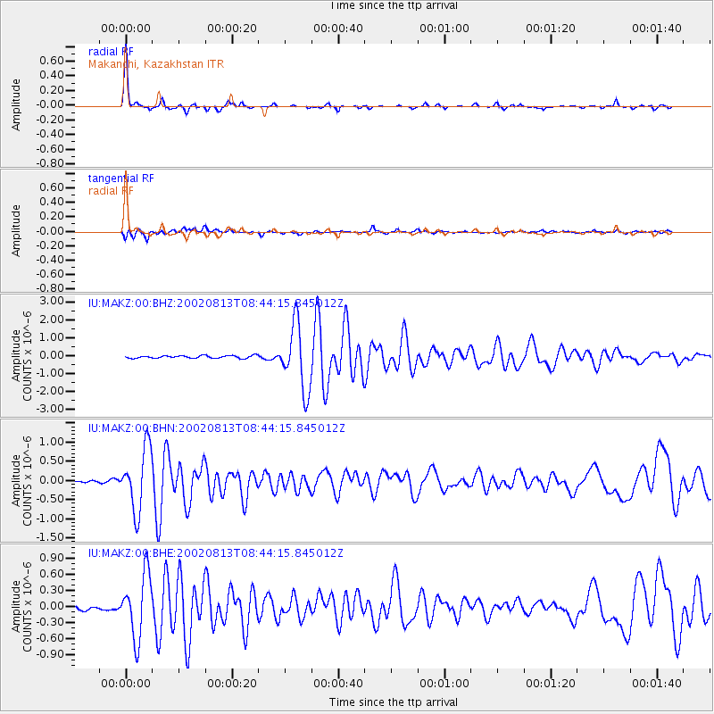
Signal To Noise
| Channel | StoN | STA | LTA |
| IU:MAKZ:00:BHN:20020813T08:44:15.845012Z | 17.808393 | 8.24292E-7 | 4.6286708E-8 |
| IU:MAKZ:00:BHE:20020813T08:44:15.845012Z | 14.22987 | 5.969288E-7 | 4.1949E-8 |
| IU:MAKZ:00:BHZ:20020813T08:44:15.845012Z | 25.353725 | 1.8316294E-6 | 7.224301E-8 |
| Arrivals |
| Ps | 6.9 SECOND |
| PpPs | 20 SECOND |
| PsPs/PpSs | 27 SECOND |


