You are here: Home > Network List > IU - Global Seismograph Network (GSN - IRIS/USGS) Stations List
> Station MAKZ Makanchi, Kazakhstan > Earthquake Result Viewer
MAKZ Makanchi, Kazakhstan - Earthquake Result Viewer

| Earthquake location: |
Sunda Strait, Indonesia |
| Earthquake latitude/longitude: |
-7.0/104.2 |
| Earthquake time(UTC): |
2002/06/27 (178) 05:50:35 GMT |
| Earthquake Depth: |
11 km |
| Earthquake Magnitude: |
6.0 MB, 6.9 MS, 6.6 MW, 6.5 MW |
| Earthquake Catalog/Contributor: |
WHDF/NEIC |
|
| Network: |
IU Global Seismograph Network (GSN - IRIS/USGS) |
| Station: |
MAKZ Makanchi, Kazakhstan |
| Lat/Lon: |
46.81 N/81.98 E |
| Elevation: |
600 m |
|
| Distance: |
57.1 deg |
| Az: |
341.982 deg |
| Baz: |
153.447 deg |
| Ray Param: |
0.06373324 |
| Estimated Moho Depth: |
54.25 km |
| Estimated Crust Vp/Vs: |
1.68 |
| Assumed Crust Vp: |
6.571 km/s |
| Estimated Crust Vs: |
3.911 km/s |
| Estimated Crust Poisson's Ratio: |
0.23 |
|
| Radial Match: |
96.509575 % |
| Radial Bump: |
400 |
| Transverse Match: |
87.53615 % |
| Transverse Bump: |
400 |
| SOD ConfigId: |
20082 |
| Insert Time: |
2010-03-04 19:37:19.311 +0000 |
| GWidth: |
2.5 |
| Max Bumps: |
400 |
| Tol: |
0.001 |
|
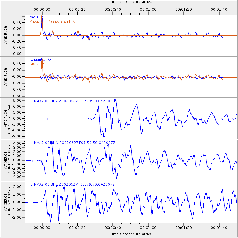
Signal To Noise
| Channel | StoN | STA | LTA |
| IU:MAKZ:00:BHN:20020627T05:59:50.042007Z | 52.4789 | 2.187398E-6 | 4.1681474E-8 |
| IU:MAKZ:00:BHE:20020627T05:59:50.042007Z | 39.2464 | 1.1834699E-6 | 3.0154865E-8 |
| IU:MAKZ:00:BHZ:20020627T05:59:50.042007Z | 116.57097 | 5.028449E-6 | 4.313637E-8 |
| Arrivals |
| Ps | 5.9 SECOND |
| PpPs | 21 SECOND |
| PsPs/PpSs | 27 SECOND |


