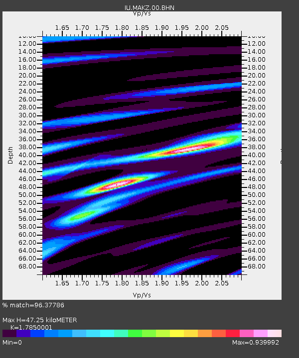
MAKZ Makanchi, Kazakhstan - Earthquake Result Viewer

Earthquake location: W. Caroline Islands, Micronesia
Earthquake latitude/longitude: 11.0/140.7
Earthquake time(UTC): 2002/06/10 (161) 22:48:36 GMT
Earthquake Depth: 33 km
Earthquake Magnitude: 5.9 MB, 5.9 MS, 6.1 MW, 6.0 MW
Earthquake Catalog/Contributor: WHDF/NEIC
Network: IU Global Seismograph Network (GSN - IRIS/USGS)
Station: MAKZ Makanchi, Kazakhstan
Lat/Lon: 46.81 N/81.98 E
Elevation: 600 m
Distance: 60.8 deg
Az: 317.744 deg
Baz: 105.997 deg
Ray Param: 0.061236493
Estimated Moho Depth: 47.25 km
Estimated Crust Vp/Vs: 1.79
Assumed Crust Vp: 6.571 km/s
Estimated Crust Vs: 3.681 km/s
Estimated Crust Poisson's Ratio: 0.27
Radial Match: 96.37786 %
Radial Bump: 198
Transverse Match: 87.72222 %
Transverse Bump: 400
SOD ConfigId: 20082
Insert Time: 2010-03-04 19:37:31.155 +0000
GWidth: 2.5
Max Bumps: 400
Tol: 0.001

Signal To Noise

ChannelStoNSTALTA
IU:MAKZ:00:BHN:20020610T22:58:14.241006Z1.18402614.1372097E-83.4941877E-8
IU:MAKZ:00:BHE:20020610T22:58:14.241006Z6.0678911.8833171E-73.1037427E-8
IU:MAKZ:00:BHZ:20020610T22:58:14.241006Z8.0435284.3635617E-75.4249355E-8
Arrivals
Ps5.9 SECOND
PpPs19 SECOND
PsPs/PpSs25 SECOND