You are here: Home > Network List > UW - Pacific Northwest Regional Seismic Network Stations List
> Station MRBL Marblemount, WA, USA > Earthquake Result Viewer
MRBL Marblemount, WA, USA - Earthquake Result Viewer
| Earthquake location: |
Near Coast Of Central Chile |
| Earthquake latitude/longitude: |
-31.6/-71.8 |
| Earthquake time(UTC): |
2015/09/16 (259) 22:54:31 GMT |
| Earthquake Depth: |
12 km |
| Earthquake Magnitude: |
8.3 MWW, 7.9 MI |
| Earthquake Catalog/Contributor: |
NEIC PDE/NEIC COMCAT |
|
| Network: |
UW Pacific Northwest Regional Seismic Network |
| Station: |
MRBL Marblemount, WA, USA |
| Lat/Lon: |
48.52 N/121.48 W |
| Elevation: |
75 m |
|
| Distance: |
91.3 deg |
| Az: |
329.506 deg |
| Baz: |
139.354 deg |
| Ray Param: |
0.041612215 |
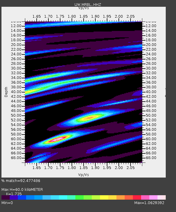
| Estimated Moho Depth: |
60.0 km |
| Estimated Crust Vp/Vs: |
1.74 |
| Assumed Crust Vp: |
6.566 km/s |
| Estimated Crust Vs: |
3.785 km/s |
| Estimated Crust Poisson's Ratio: |
0.25 |
|
| Radial Match: |
92.477486 % |
| Radial Bump: |
400 |
| Transverse Match: |
91.57486 % |
| Transverse Bump: |
400 |
| SOD ConfigId: |
7422571 |
| Insert Time: |
2019-04-20 19:07:33.486 +0000 |
| GWidth: |
2.5 |
| Max Bumps: |
400 |
| Tol: |
0.001 |
|
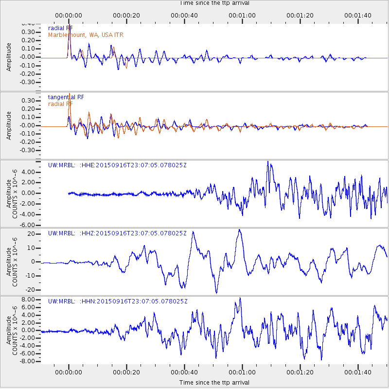
Signal To Noise
| Channel | StoN | STA | LTA |
| UW:MRBL: :HHZ:20150916T23:07:05.078025Z | 5.175761 | 7.529113E-7 | 1.4546872E-7 |
| UW:MRBL: :HHN:20150916T23:07:05.078025Z | 1.4665853 | 2.4456727E-7 | 1.6675968E-7 |
| UW:MRBL: :HHE:20150916T23:07:05.078025Z | 1.393409 | 1.9567506E-7 | 1.4042902E-7 |
| Arrivals |
| Ps | 6.9 SECOND |
| PpPs | 24 SECOND |
| PsPs/PpSs | 31 SECOND |


