You are here: Home > Network List > UW - Pacific Northwest Regional Seismic Network Stations List
> Station RADR Rader Ridge, WA > Earthquake Result Viewer
RADR Rader Ridge, WA - Earthquake Result Viewer
| Earthquake location: |
Near Coast Of Central Chile |
| Earthquake latitude/longitude: |
-31.6/-71.8 |
| Earthquake time(UTC): |
2015/09/16 (259) 22:54:31 GMT |
| Earthquake Depth: |
12 km |
| Earthquake Magnitude: |
8.3 MWW, 7.9 MI |
| Earthquake Catalog/Contributor: |
NEIC PDE/NEIC COMCAT |
|
| Network: |
UW Pacific Northwest Regional Seismic Network |
| Station: |
RADR Rader Ridge, WA |
| Lat/Lon: |
46.42 N/123.80 W |
| Elevation: |
568 m |
|
| Distance: |
90.8 deg |
| Az: |
326.94 deg |
| Baz: |
137.699 deg |
| Ray Param: |
0.041650128 |
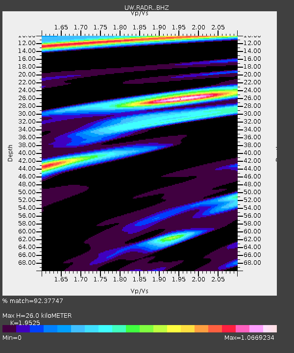
| Estimated Moho Depth: |
26.0 km |
| Estimated Crust Vp/Vs: |
1.95 |
| Assumed Crust Vp: |
6.566 km/s |
| Estimated Crust Vs: |
3.363 km/s |
| Estimated Crust Poisson's Ratio: |
0.32 |
|
| Radial Match: |
92.37747 % |
| Radial Bump: |
400 |
| Transverse Match: |
89.74405 % |
| Transverse Bump: |
400 |
| SOD ConfigId: |
7422571 |
| Insert Time: |
2019-04-20 19:07:36.972 +0000 |
| GWidth: |
2.5 |
| Max Bumps: |
400 |
| Tol: |
0.001 |
|

Signal To Noise
| Channel | StoN | STA | LTA |
| UW:RADR: :BHZ:20150916T23:07:02.639976Z | 1.8440293 | 9.138042E-7 | 4.955475E-7 |
| UW:RADR: :BHN:20150916T23:07:02.639976Z | 1.351259 | 8.702822E-7 | 6.440529E-7 |
| UW:RADR: :BHE:20150916T23:07:02.639976Z | 2.1146684 | 1.1918896E-6 | 5.6362956E-7 |
| Arrivals |
| Ps | 3.8 SECOND |
| PpPs | 11 SECOND |
| PsPs/PpSs | 15 SECOND |


