You are here: Home > Network List > WI - West Indies IPGP Network Stations List
> Station MAGL Barre de l'ile, Marie-Galante, Guadeloupe > Earthquake Result Viewer
MAGL Barre de l'ile, Marie-Galante, Guadeloupe - Earthquake Result Viewer
| Earthquake location: |
Near Coast Of Central Chile |
| Earthquake latitude/longitude: |
-31.6/-71.8 |
| Earthquake time(UTC): |
2015/09/16 (259) 22:54:31 GMT |
| Earthquake Depth: |
12 km |
| Earthquake Magnitude: |
8.3 MWW, 7.9 MI |
| Earthquake Catalog/Contributor: |
NEIC PDE/NEIC COMCAT |
|
| Network: |
WI West Indies IPGP Network |
| Station: |
MAGL Barre de l'ile, Marie-Galante, Guadeloupe |
| Lat/Lon: |
15.95 N/61.28 W |
| Elevation: |
159 m |
|
| Distance: |
48.3 deg |
| Az: |
13.537 deg |
| Baz: |
191.985 deg |
| Ray Param: |
0.06943378 |
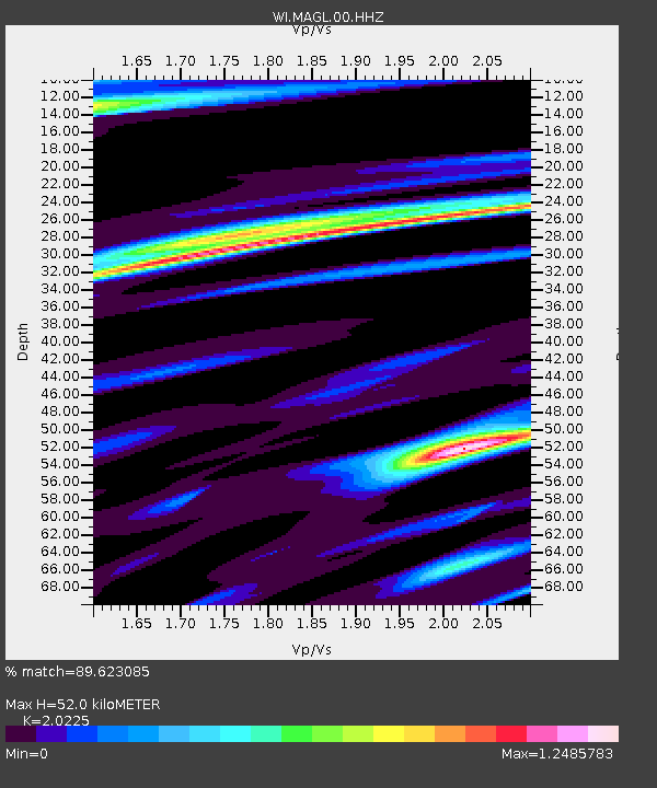
| Estimated Moho Depth: |
52.0 km |
| Estimated Crust Vp/Vs: |
2.02 |
| Assumed Crust Vp: |
5.88 km/s |
| Estimated Crust Vs: |
2.907 km/s |
| Estimated Crust Poisson's Ratio: |
0.34 |
|
| Radial Match: |
89.623085 % |
| Radial Bump: |
400 |
| Transverse Match: |
72.71196 % |
| Transverse Bump: |
400 |
| SOD ConfigId: |
7422571 |
| Insert Time: |
2019-04-20 19:07:57.196 +0000 |
| GWidth: |
2.5 |
| Max Bumps: |
400 |
| Tol: |
0.001 |
|
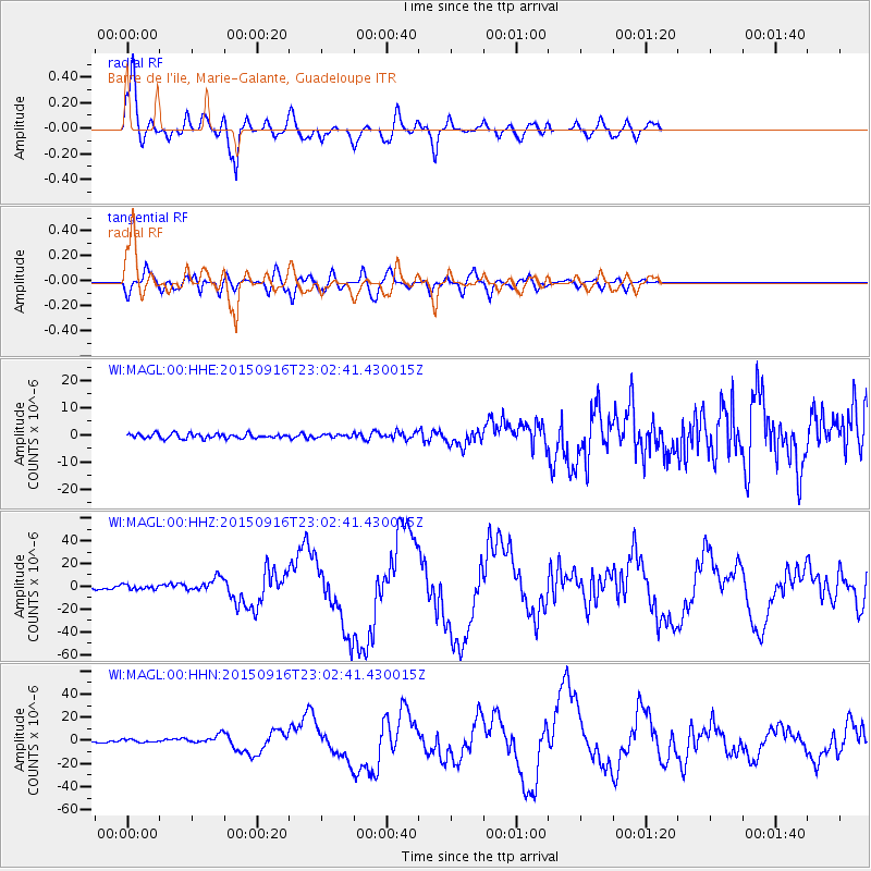
Signal To Noise
| Channel | StoN | STA | LTA |
| WI:MAGL:00:HHZ:20150916T23:02:41.430015Z | 2.6595697 | 2.1371209E-6 | 8.035589E-7 |
| WI:MAGL:00:HHN:20150916T23:02:41.430015Z | 1.3761388 | 1.2771061E-6 | 9.280358E-7 |
| WI:MAGL:00:HHE:20150916T23:02:41.430015Z | 0.65883523 | 5.791791E-7 | 8.7909547E-7 |
| Arrivals |
| Ps | 9.4 SECOND |
| PpPs | 26 SECOND |
| PsPs/PpSs | 35 SECOND |


