You are here: Home > Network List > XD14 - Illuminating the architecture of the greater Mount St. Helens magmatic systems f Stations List
> Station MG08 "Mount St Helens, WA" > Earthquake Result Viewer
MG08 "Mount St Helens, WA" - Earthquake Result Viewer
| Earthquake location: |
Near Coast Of Central Chile |
| Earthquake latitude/longitude: |
-31.6/-71.8 |
| Earthquake time(UTC): |
2015/09/16 (259) 22:54:31 GMT |
| Earthquake Depth: |
12 km |
| Earthquake Magnitude: |
8.3 MWW, 7.9 MI |
| Earthquake Catalog/Contributor: |
NEIC PDE/NEIC COMCAT |
|
| Network: |
XD Illuminating the architecture of the greater Mount St. Helens magmatic systems f |
| Station: |
MG08 "Mount St Helens, WA" |
| Lat/Lon: |
46.34 N/121.93 W |
| Elevation: |
1547 m |
|
| Distance: |
89.8 deg |
| Az: |
327.854 deg |
| Baz: |
139.044 deg |
| Ray Param: |
0.04171574 |
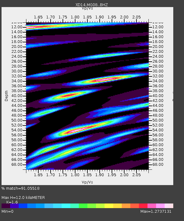
| Estimated Moho Depth: |
12.0 km |
| Estimated Crust Vp/Vs: |
1.60 |
| Assumed Crust Vp: |
6.597 km/s |
| Estimated Crust Vs: |
4.123 km/s |
| Estimated Crust Poisson's Ratio: |
0.18 |
|
| Radial Match: |
91.05518 % |
| Radial Bump: |
400 |
| Transverse Match: |
87.94013 % |
| Transverse Bump: |
400 |
| SOD ConfigId: |
7422571 |
| Insert Time: |
2019-04-20 19:08:32.295 +0000 |
| GWidth: |
2.5 |
| Max Bumps: |
400 |
| Tol: |
0.001 |
|

Signal To Noise
| Channel | StoN | STA | LTA |
| XD:MG08: :BHZ:20150916T23:06:58.380027Z | 8.223703 | 1.3353944E-6 | 1.6238357E-7 |
| XD:MG08: :BHN:20150916T23:06:58.380027Z | 1.3213207 | 3.9278848E-7 | 2.9726962E-7 |
| XD:MG08: :BHE:20150916T23:06:58.380027Z | 1.3698949 | 2.8817934E-7 | 2.1036603E-7 |
| Arrivals |
| Ps | 1.1 SECOND |
| PpPs | 4.6 SECOND |
| PsPs/PpSs | 5.7 SECOND |


