You are here: Home > Network List > IU - Global Seismograph Network (GSN - IRIS/USGS) Stations List
> Station MAKZ Makanchi, Kazakhstan > Earthquake Result Viewer
MAKZ Makanchi, Kazakhstan - Earthquake Result Viewer
| Earthquake location: |
Mindanao, Philippines |
| Earthquake latitude/longitude: |
6.0/124.2 |
| Earthquake time(UTC): |
2002/03/05 (064) 21:16:09 GMT |
| Earthquake Depth: |
31 km |
| Earthquake Magnitude: |
6.3 MB, 7.2 MS, 7.5 MW, 7.2 MW |
| Earthquake Catalog/Contributor: |
WHDF/NEIC |
|
| Network: |
IU Global Seismograph Network (GSN - IRIS/USGS) |
| Station: |
MAKZ Makanchi, Kazakhstan |
| Lat/Lon: |
46.81 N/81.98 E |
| Elevation: |
600 m |
|
| Distance: |
54.5 deg |
| Az: |
325.399 deg |
| Baz: |
124.694 deg |
| Ray Param: |
0.0653861 |
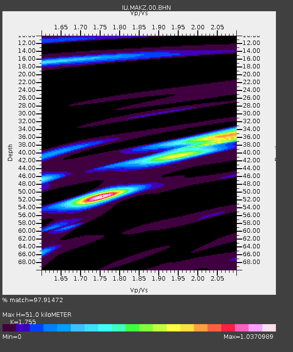
| Estimated Moho Depth: |
51.0 km |
| Estimated Crust Vp/Vs: |
1.75 |
| Assumed Crust Vp: |
6.571 km/s |
| Estimated Crust Vs: |
3.744 km/s |
| Estimated Crust Poisson's Ratio: |
0.26 |
|
| Radial Match: |
97.91472 % |
| Radial Bump: |
240 |
| Transverse Match: |
88.951805 % |
| Transverse Bump: |
400 |
| SOD ConfigId: |
20082 |
| Insert Time: |
2010-03-04 19:38:09.330 +0000 |
| GWidth: |
2.5 |
| Max Bumps: |
400 |
| Tol: |
0.001 |
|
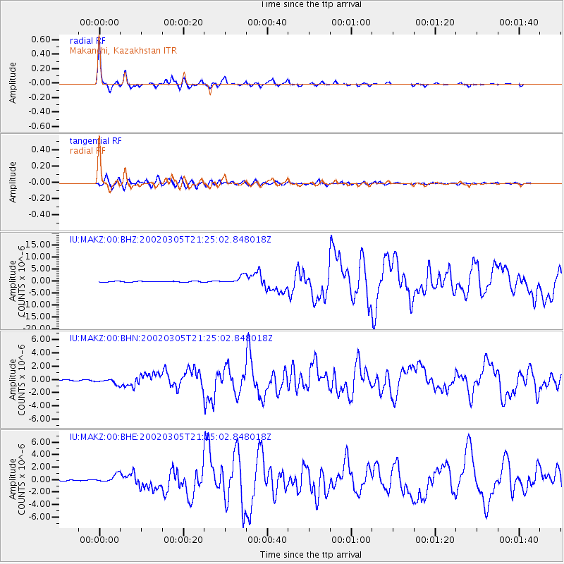
Signal To Noise
| Channel | StoN | STA | LTA |
| IU:MAKZ:00:BHN:20020305T21:25:02.848018Z | 8.472356 | 3.9941241E-7 | 4.714302E-8 |
| IU:MAKZ:00:BHE:20020305T21:25:02.848018Z | 7.3582067 | 6.618376E-7 | 8.99455E-8 |
| IU:MAKZ:00:BHZ:20020305T21:25:02.848018Z | 9.77529 | 1.6476317E-6 | 1.6855068E-7 |
| Arrivals |
| Ps | 6.2 SECOND |
| PpPs | 20 SECOND |
| PsPs/PpSs | 26 SECOND |


