You are here: Home > Network List > YQ13 - Study of Extension and Magmatism in Malawi and Tanzania Stations List
> Station NTHA Nthalire,Malawi > Earthquake Result Viewer
NTHA Nthalire,Malawi - Earthquake Result Viewer
| Earthquake location: |
Near Coast Of Central Chile |
| Earthquake latitude/longitude: |
-31.5/-71.9 |
| Earthquake time(UTC): |
2015/09/16 (259) 22:59:17 GMT |
| Earthquake Depth: |
48 km |
| Earthquake Magnitude: |
6.3 MB |
| Earthquake Catalog/Contributor: |
NEIC PDE/NEIC COMCAT |
|
| Network: |
YQ Study of Extension and Magmatism in Malawi and Tanzania |
| Station: |
NTHA Nthalire,Malawi |
| Lat/Lon: |
10.35 S/33.64 E |
| Elevation: |
1291 m |
|
| Distance: |
97.6 deg |
| Az: |
106.997 deg |
| Baz: |
236.084 deg |
| Ray Param: |
0.040134974 |
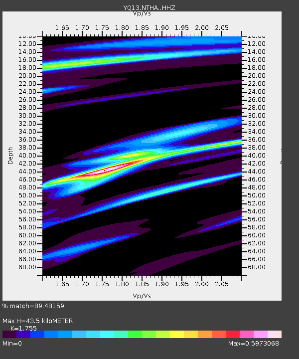
| Estimated Moho Depth: |
43.5 km |
| Estimated Crust Vp/Vs: |
1.75 |
| Assumed Crust Vp: |
6.367 km/s |
| Estimated Crust Vs: |
3.628 km/s |
| Estimated Crust Poisson's Ratio: |
0.26 |
|
| Radial Match: |
89.48159 % |
| Radial Bump: |
342 |
| Transverse Match: |
63.844913 % |
| Transverse Bump: |
400 |
| SOD ConfigId: |
7422571 |
| Insert Time: |
2019-04-20 19:16:35.889 +0000 |
| GWidth: |
2.5 |
| Max Bumps: |
400 |
| Tol: |
0.001 |
|

Signal To Noise
| Channel | StoN | STA | LTA |
| YQ:NTHA: :HHZ:20150916T23:12:14.549985Z | 1.3663187 | 9.501869E-6 | 6.954357E-6 |
| YQ:NTHA: :HHN:20150916T23:12:14.549985Z | 1.2148818 | 3.4660657E-6 | 2.8530067E-6 |
| YQ:NTHA: :HHE:20150916T23:12:14.549985Z | 1.1678107 | 5.096264E-6 | 4.3639475E-6 |
| Arrivals |
| Ps | 5.3 SECOND |
| PpPs | 18 SECOND |
| PsPs/PpSs | 24 SECOND |


