You are here: Home > Network List > IU - Global Seismograph Network (GSN - IRIS/USGS) Stations List
> Station MAKZ Makanchi, Kazakhstan > Earthquake Result Viewer
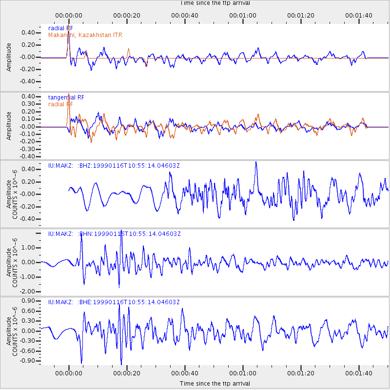
MAKZ Makanchi, Kazakhstan - Earthquake Result Viewer
*The percent match for this event was below the threshold and hence no stack was calculated.
| Earthquake location: |
Gulf Of Alaska |
| Earthquake latitude/longitude: |
56.2/-147.4 |
| Earthquake time(UTC): |
1999/01/16 (016) 10:44:39 GMT |
| Earthquake Depth: |
21 km |
| Earthquake Magnitude: |
5.9 MB, 5.7 MS, 6.0 MW, 6.0 ME |
| Earthquake Catalog/Contributor: |
WHDF/NEIC |
|
| Network: |
IU Global Seismograph Network (GSN - IRIS/USGS) |
| Station: |
MAKZ Makanchi, Kazakhstan |
| Lat/Lon: |
46.81 N/81.98 E |
| Elevation: |
600 m |
|
| Distance: |
69.3 deg |
| Az: |
326.115 deg |
| Baz: |
26.951 deg |
| Ray Param: |
$rayparam |
*The percent match for this event was below the threshold and hence was not used in the summary stack. |
|
| Radial Match: |
74.15129 % |
| Radial Bump: |
367 |
| Transverse Match: |
78.194824 % |
| Transverse Bump: |
400 |
| SOD ConfigId: |
4480 |
| Insert Time: |
2010-03-04 19:39:25.358 +0000 |
| GWidth: |
2.5 |
| Max Bumps: |
400 |
| Tol: |
0.001 |
|
Signal To Noise
| Channel | StoN | STA | LTA |
| IU:MAKZ: :BHN:19990116T10:55:14.04603Z | 3.9204133 | 5.6458776E-7 | 1.440123E-7 |
| IU:MAKZ: :BHE:19990116T10:55:14.04603Z | 2.7980382 | 2.9383244E-7 | 1.05013726E-7 |
| IU:MAKZ: :BHZ:19990116T10:55:14.04603Z | 1.6050549 | 1.6806943E-7 | 1.0471258E-7 |
| Arrivals |
| Ps | |
| PpPs | |
| PsPs/PpSs | |


