You are here: Home > Network List > IU - Global Seismograph Network (GSN - IRIS/USGS) Stations List
> Station MAKZ Makanchi, Kazakhstan > Earthquake Result Viewer
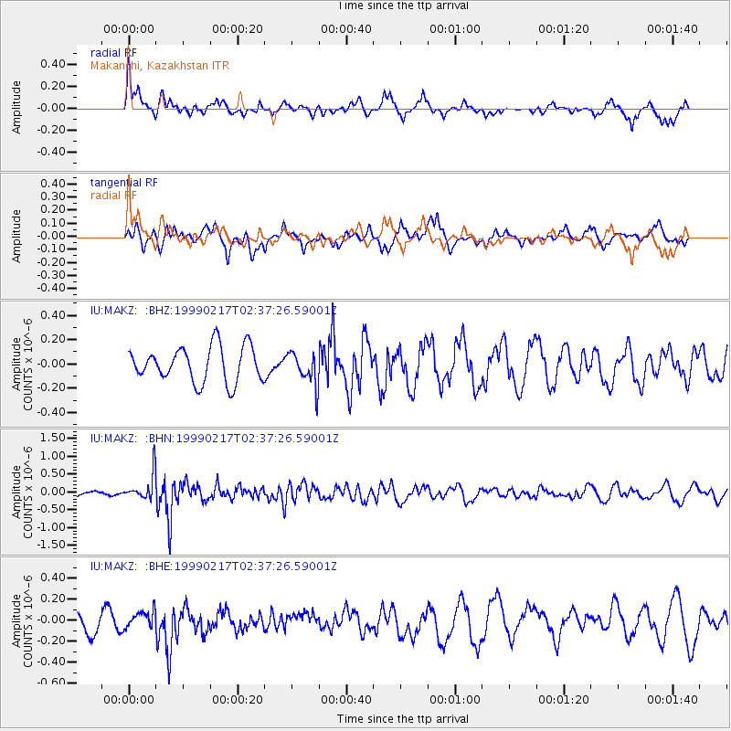
MAKZ Makanchi, Kazakhstan - Earthquake Result Viewer
*The percent match for this event was below the threshold and hence no stack was calculated.
| Earthquake location: |
Irian Jaya Region, Indonesia |
| Earthquake latitude/longitude: |
-2.0/133.5 |
| Earthquake time(UTC): |
1999/02/17 (048) 02:27:12 GMT |
| Earthquake Depth: |
33 km |
| Earthquake Magnitude: |
5.7 MW, 5.4 MS, 5.4 MB, 5.6 MW |
| Earthquake Catalog/Contributor: |
WHDF/NEIC |
|
| Network: |
IU Global Seismograph Network (GSN - IRIS/USGS) |
| Station: |
MAKZ Makanchi, Kazakhstan |
| Lat/Lon: |
46.81 N/81.98 E |
| Elevation: |
600 m |
|
| Distance: |
66.3 deg |
| Az: |
324.047 deg |
| Baz: |
121.324 deg |
| Ray Param: |
$rayparam |
*The percent match for this event was below the threshold and hence was not used in the summary stack. |
|
| Radial Match: |
64.40187 % |
| Radial Bump: |
378 |
| Transverse Match: |
61.42542 % |
| Transverse Bump: |
400 |
| SOD ConfigId: |
4480 |
| Insert Time: |
2010-03-04 19:39:40.914 +0000 |
| GWidth: |
2.5 |
| Max Bumps: |
400 |
| Tol: |
0.001 |
|
Signal To Noise
| Channel | StoN | STA | LTA |
| IU:MAKZ: :BHN:19990217T02:37:26.59001Z | 4.0553145 | 3.7468553E-7 | 9.2393705E-8 |
| IU:MAKZ: :BHE:19990217T02:37:26.59001Z | 0.9767701 | 7.7953345E-8 | 7.980726E-8 |
| IU:MAKZ: :BHZ:19990217T02:37:26.59001Z | 0.91514826 | 1.3245871E-7 | 1.4474017E-7 |
| Arrivals |
| Ps | |
| PpPs | |
| PsPs/PpSs | |


