You are here: Home > Network List > IU - Global Seismograph Network (GSN - IRIS/USGS) Stations List
> Station MAKZ Makanchi, Kazakhstan > Earthquake Result Viewer
MAKZ Makanchi, Kazakhstan - Earthquake Result Viewer
*The percent match for this event was below the threshold and hence no stack was calculated.
| Earthquake location: |
Off East Coast Of Kamchatka |
| Earthquake latitude/longitude: |
54.0/161.9 |
| Earthquake time(UTC): |
1997/12/06 (340) 10:59:10 GMT |
| Earthquake Depth: |
33 km |
| Earthquake Magnitude: |
5.7 MB, 5.8 MS, 6.1 UNKNOWN, 6.1 MW |
| Earthquake Catalog/Contributor: |
WHDF/NEIC |
|
| Network: |
IU Global Seismograph Network (GSN - IRIS/USGS) |
| Station: |
MAKZ Makanchi, Kazakhstan |
| Lat/Lon: |
46.81 N/81.98 E |
| Elevation: |
600 m |
|
| Distance: |
48.9 deg |
| Az: |
296.178 deg |
| Baz: |
50.52 deg |
| Ray Param: |
$rayparam |
*The percent match for this event was below the threshold and hence was not used in the summary stack. |
|
| Radial Match: |
63.239758 % |
| Radial Bump: |
355 |
| Transverse Match: |
42.42992 % |
| Transverse Bump: |
333 |
| SOD ConfigId: |
4480 |
| Insert Time: |
2010-03-04 19:39:58.971 +0000 |
| GWidth: |
2.5 |
| Max Bumps: |
400 |
| Tol: |
0.001 |
|
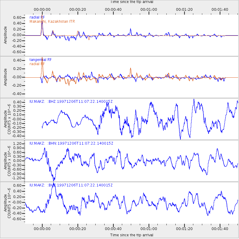
Signal To Noise
| Channel | StoN | STA | LTA |
| IU:MAKZ: :BHN:19971206T11:07:22.140015Z | 2.6882703 | 4.6174048E-7 | 1.7176117E-7 |
| IU:MAKZ: :BHE:19971206T11:07:22.140015Z | 0.8035843 | 2.4547094E-7 | 3.0547008E-7 |
| IU:MAKZ: :BHZ:19971206T11:07:22.140015Z | 1.551573 | 1.6673278E-7 | 1.0746047E-7 |
| Arrivals |
| Ps | |
| PpPs | |
| PsPs/PpSs | |


