You are here: Home > Network List > IU - Global Seismograph Network (GSN - IRIS/USGS) Stations List
> Station WAKE Wake Island > Earthquake Result Viewer
WAKE Wake Island - Earthquake Result Viewer
| Earthquake location: |
Banda Sea |
| Earthquake latitude/longitude: |
-5.5/128.1 |
| Earthquake time(UTC): |
2006/01/27 (027) 16:58:53 GMT |
| Earthquake Depth: |
397 km |
| Earthquake Magnitude: |
7.0 MB, 7.6 MW, 7.5 MW |
| Earthquake Catalog/Contributor: |
WHDF/NEIC |
|
| Network: |
IU Global Seismograph Network (GSN - IRIS/USGS) |
| Station: |
WAKE Wake Island |
| Lat/Lon: |
19.28 N/166.65 E |
| Elevation: |
1.0 m |
|
| Distance: |
45.2 deg |
| Az: |
56.001 deg |
| Baz: |
240.896 deg |
| Ray Param: |
0.06970312 |
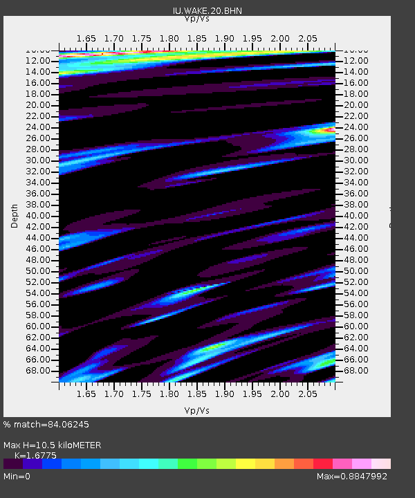
| Estimated Moho Depth: |
10.5 km |
| Estimated Crust Vp/Vs: |
1.68 |
| Assumed Crust Vp: |
4.24 km/s |
| Estimated Crust Vs: |
2.528 km/s |
| Estimated Crust Poisson's Ratio: |
0.22 |
|
| Radial Match: |
84.06245 % |
| Radial Bump: |
400 |
| Transverse Match: |
66.81016 % |
| Transverse Bump: |
400 |
| SOD ConfigId: |
4977 |
| Insert Time: |
2010-03-04 19:40:07.136 +0000 |
| GWidth: |
2.5 |
| Max Bumps: |
400 |
| Tol: |
0.001 |
|

Signal To Noise
| Channel | StoN | STA | LTA |
| IU:WAKE:20:BHN:20060127T17:06:02.547014Z | 1.2061446 | 1.383362E-5 | 1.14692875E-5 |
| IU:WAKE:20:BHE:20060127T17:06:02.547014Z | 1.6728885 | 1.5064692E-5 | 9.005198E-6 |
| IU:WAKE:20:BHZ:20060127T17:06:02.547014Z | 6.051137 | 2.177701E-5 | 3.5988292E-6 |
| Arrivals |
| Ps | 1.7 SECOND |
| PpPs | 6.5 SECOND |
| PsPs/PpSs | 8.2 SECOND |


