You are here: Home > Network List > CI - Caltech Regional Seismic Network Stations List
> Station MPM Manuel Prospect Mine, California, USA > Earthquake Result Viewer
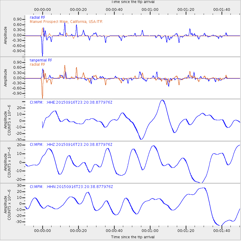
MPM Manuel Prospect Mine, California, USA - Earthquake Result Viewer
*The percent match for this event was below the threshold and hence no stack was calculated.
| Earthquake location: |
Near Coast Of Central Chile |
| Earthquake latitude/longitude: |
-31.1/-71.3 |
| Earthquake time(UTC): |
2015/09/16 (259) 23:09:05 GMT |
| Earthquake Depth: |
26 km |
| Earthquake Magnitude: |
5.6 MB |
| Earthquake Catalog/Contributor: |
NEIC PDE/NEIC COMCAT |
|
| Network: |
CI Caltech Regional Seismic Network |
| Station: |
MPM Manuel Prospect Mine, California, USA |
| Lat/Lon: |
36.06 N/117.49 W |
| Elevation: |
185 m |
|
| Distance: |
79.6 deg |
| Az: |
323.554 deg |
| Baz: |
141.037 deg |
| Ray Param: |
$rayparam |
*The percent match for this event was below the threshold and hence was not used in the summary stack. |
|
| Radial Match: |
69.954056 % |
| Radial Bump: |
400 |
| Transverse Match: |
57.582874 % |
| Transverse Bump: |
225 |
| SOD ConfigId: |
7422571 |
| Insert Time: |
2019-04-20 19:25:15.409 +0000 |
| GWidth: |
2.5 |
| Max Bumps: |
400 |
| Tol: |
0.001 |
|
Signal To Noise
| Channel | StoN | STA | LTA |
| CI:MPM: :HHZ:20150916T23:20:38.877976Z | 2.9087634 | 1.272202E-5 | 4.373687E-6 |
| CI:MPM: :HHN:20150916T23:20:38.877976Z | 0.21286243 | 2.1580945E-6 | 1.0138448E-5 |
| CI:MPM: :HHE:20150916T23:20:38.877976Z | 0.8376727 | 5.1995594E-6 | 6.207149E-6 |
| Arrivals |
| Ps | |
| PpPs | |
| PsPs/PpSs | |


