You are here: Home > Network List > MB - Montana Regional Seismic Network Stations List
> Station JTMT Jette Lake, Montana > Earthquake Result Viewer
JTMT Jette Lake, Montana - Earthquake Result Viewer
| Earthquake location: |
Near Coast Of Chiapas, Mexico |
| Earthquake latitude/longitude: |
14.9/-94.0 |
| Earthquake time(UTC): |
2015/05/10 (130) 00:50:18 GMT |
| Earthquake Depth: |
6.7 km |
| Earthquake Magnitude: |
5.6 MB |
| Earthquake Catalog/Contributor: |
NEIC PDE/NEIC COMCAT |
|
| Network: |
MB Montana Regional Seismic Network |
| Station: |
JTMT Jette Lake, Montana |
| Lat/Lon: |
47.75 N/114.28 W |
| Elevation: |
1469 m |
|
| Distance: |
36.8 deg |
| Az: |
337.028 deg |
| Baz: |
146.001 deg |
| Ray Param: |
0.0764645 |
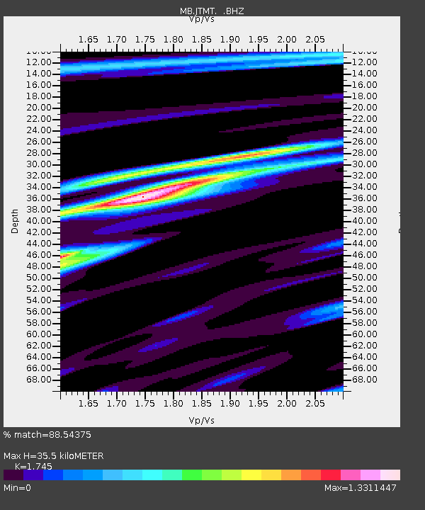
| Estimated Moho Depth: |
35.5 km |
| Estimated Crust Vp/Vs: |
1.75 |
| Assumed Crust Vp: |
6.622 km/s |
| Estimated Crust Vs: |
3.795 km/s |
| Estimated Crust Poisson's Ratio: |
0.26 |
|
| Radial Match: |
88.54375 % |
| Radial Bump: |
285 |
| Transverse Match: |
66.98011 % |
| Transverse Bump: |
400 |
| SOD ConfigId: |
976571 |
| Insert Time: |
2015-05-24 01:16:15.152 +0000 |
| GWidth: |
2.5 |
| Max Bumps: |
400 |
| Tol: |
0.001 |
|

Signal To Noise
| Channel | StoN | STA | LTA |
| MB:JTMT: :BHZ:20150510T00:56:56.235005Z | 9.604004 | 6.692353E-7 | 6.968295E-8 |
| MB:JTMT: :BHN:20150510T00:56:56.235005Z | 6.7342257 | 4.2653383E-7 | 6.333821E-8 |
| MB:JTMT: :BHE:20150510T00:56:56.235005Z | 3.1793537 | 2.5797942E-7 | 8.114209E-8 |
| Arrivals |
| Ps | 4.3 SECOND |
| PpPs | 14 SECOND |
| PsPs/PpSs | 18 SECOND |


