You are here: Home > Network List > TA - USArray Transportable Network (new EarthScope stations) Stations List
> Station Z41A Richland Creek Farm, El Dorado, AR, USA > Earthquake Result Viewer
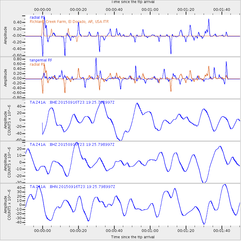
Z41A Richland Creek Farm, El Dorado, AR, USA - Earthquake Result Viewer
*The percent match for this event was below the threshold and hence no stack was calculated.
| Earthquake location: |
Near Coast Of Central Chile |
| Earthquake latitude/longitude: |
-31.1/-71.3 |
| Earthquake time(UTC): |
2015/09/16 (259) 23:09:05 GMT |
| Earthquake Depth: |
26 km |
| Earthquake Magnitude: |
5.6 MB |
| Earthquake Catalog/Contributor: |
NEIC PDE/NEIC COMCAT |
|
| Network: |
TA USArray Transportable Network (new EarthScope stations) |
| Station: |
Z41A Richland Creek Farm, El Dorado, AR, USA |
| Lat/Lon: |
33.26 N/92.80 W |
| Elevation: |
62 m |
|
| Distance: |
67.2 deg |
| Az: |
340.569 deg |
| Baz: |
160.091 deg |
| Ray Param: |
$rayparam |
*The percent match for this event was below the threshold and hence was not used in the summary stack. |
|
| Radial Match: |
31.13654 % |
| Radial Bump: |
295 |
| Transverse Match: |
49.588467 % |
| Transverse Bump: |
231 |
| SOD ConfigId: |
7422571 |
| Insert Time: |
2019-04-20 19:29:00.807 +0000 |
| GWidth: |
2.5 |
| Max Bumps: |
400 |
| Tol: |
0.001 |
|
Signal To Noise
| Channel | StoN | STA | LTA |
| TA:Z41A: :BHZ:20150916T23:19:25.798997Z | 1.1117535 | 1.5153507E-5 | 1.3630277E-5 |
| TA:Z41A: :BHN:20150916T23:19:25.798997Z | 1.4290326 | 2.4911486E-5 | 1.7432412E-5 |
| TA:Z41A: :BHE:20150916T23:19:25.798997Z | 2.2067244 | 4.4478613E-5 | 2.0155943E-5 |
| Arrivals |
| Ps | |
| PpPs | |
| PsPs/PpSs | |


