You are here: Home > Network List > IU - Global Seismograph Network (GSN - IRIS/USGS) Stations List
> Station RSSD Black Hills, South Dakota, USA > Earthquake Result Viewer
RSSD Black Hills, South Dakota, USA - Earthquake Result Viewer
| Earthquake location: |
Chile-Bolivia Border Region |
| Earthquake latitude/longitude: |
-22.3/-67.9 |
| Earthquake time(UTC): |
2005/11/17 (321) 19:26:56 GMT |
| Earthquake Depth: |
163 km |
| Earthquake Magnitude: |
6.0 MB, 6.9 MW, 6.8 MW |
| Earthquake Catalog/Contributor: |
WHDF/NEIC |
|
| Network: |
IU Global Seismograph Network (GSN - IRIS/USGS) |
| Station: |
RSSD Black Hills, South Dakota, USA |
| Lat/Lon: |
44.12 N/104.04 W |
| Elevation: |
2060 m |
|
| Distance: |
73.9 deg |
| Az: |
333.763 deg |
| Baz: |
145.362 deg |
| Ray Param: |
0.052241266 |
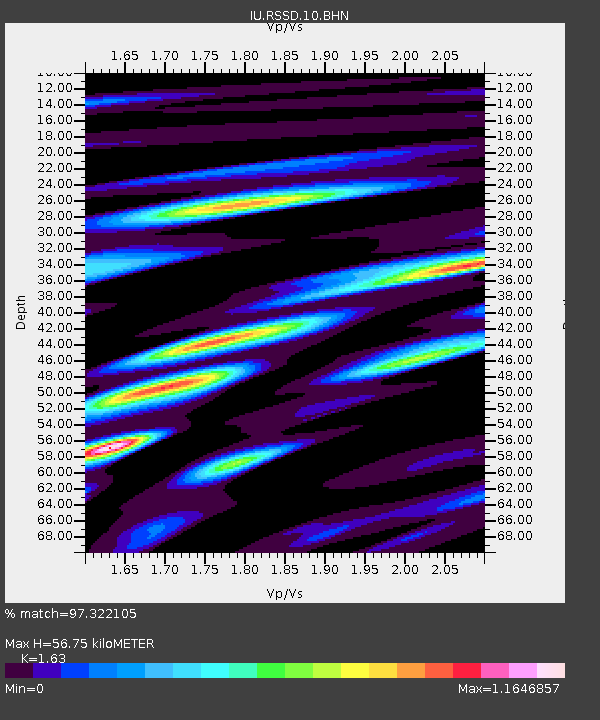
| Estimated Moho Depth: |
56.75 km |
| Estimated Crust Vp/Vs: |
1.63 |
| Assumed Crust Vp: |
6.242 km/s |
| Estimated Crust Vs: |
3.829 km/s |
| Estimated Crust Poisson's Ratio: |
0.20 |
|
| Radial Match: |
97.322105 % |
| Radial Bump: |
400 |
| Transverse Match: |
88.8164 % |
| Transverse Bump: |
400 |
| SOD ConfigId: |
2422 |
| Insert Time: |
2010-03-04 19:41:35.523 +0000 |
| GWidth: |
2.5 |
| Max Bumps: |
400 |
| Tol: |
0.001 |
|

Signal To Noise
| Channel | StoN | STA | LTA |
| IU:RSSD:10:BHN:20051117T19:37:42.86103Z | 19.902725 | 2.8538066E-6 | 1.4338774E-7 |
| IU:RSSD:10:BHE:20051117T19:37:42.86103Z | 15.666907 | 1.9496479E-6 | 1.2444369E-7 |
| IU:RSSD:10:BHZ:20051117T19:37:42.86103Z | 40.791893 | 7.0321103E-6 | 1.7238989E-7 |
| Arrivals |
| Ps | 5.9 SECOND |
| PpPs | 23 SECOND |
| PsPs/PpSs | 29 SECOND |


