RSSD Black Hills, South Dakota, USA - Earthquake Result Viewer
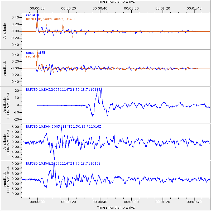
Earthquake location: Off East Coast Of Honshu, Japan
Earthquake latitude/longitude: 38.1/144.9
Earthquake time(UTC): 2005/11/14 (318) 21:38:51 GMT
Earthquake Depth: 11 km
Earthquake Magnitude: 6.7 MB, 6.8 MS, 7.0 MW, 6.9 MW
Earthquake Catalog/Contributor: WHDF/NEIC
Network: IU Global Seismograph Network (GSN - IRIS/USGS)
Station: RSSD Black Hills, South Dakota, USA
Lat/Lon: 44.12 N/104.04 W
Elevation: 2060 m
Distance: 77.2 deg
Az: 43.574 deg
Baz: 310.975 deg
Ray Param: 0.050504524
Estimated Moho Depth: 15.75 km
Estimated Crust Vp/Vs: 2.10
Assumed Crust Vp: 6.242 km/s
Estimated Crust Vs: 2.976 km/s
Estimated Crust Poisson's Ratio: 0.35
Radial Match: 98.07184 %
Radial Bump: 400
Transverse Match: 91.80788 %
Transverse Bump: 400
SOD ConfigId: 2448
Insert Time: 2010-03-04 19:41:45.931 +0000
GWidth: 2.5
Max Bumps: 400
Tol: 0.001

Signal To Noise

ChannelStoNSTALTA
IU:RSSD:10:BHN:20051114T21:50:13.711016Z4.74086488.1131907E-71.7113315E-7
IU:RSSD:10:BHE:20051114T21:50:13.711016Z12.2687791.4196453E-61.15712034E-7
IU:RSSD:10:BHZ:20051114T21:50:13.711016Z43.066234.200491E-69.75356E-8
Arrivals
Ps2.8 SECOND
PpPs7.6 SECOND
PsPs/PpSs10 SECOND