You are here: Home > Network List > TA - USArray Transportable Network (new EarthScope stations) Stations List
> Station J61A Chester, VT, USA > Earthquake Result Viewer
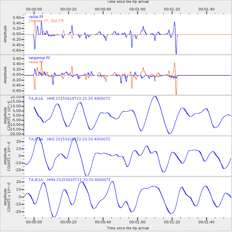
J61A Chester, VT, USA - Earthquake Result Viewer
*The percent match for this event was below the threshold and hence no stack was calculated.
| Earthquake location: |
Near Coast Of Central Chile |
| Earthquake latitude/longitude: |
-31.5/-71.7 |
| Earthquake time(UTC): |
2015/09/16 (259) 23:09:22 GMT |
| Earthquake Depth: |
10 km |
| Earthquake Magnitude: |
5.6 MB, 5.9 MB |
| Earthquake Catalog/Contributor: |
NEIC PDE/NEIC COMCAT |
|
| Network: |
TA USArray Transportable Network (new EarthScope stations) |
| Station: |
J61A Chester, VT, USA |
| Lat/Lon: |
43.35 N/72.55 W |
| Elevation: |
253 m |
|
| Distance: |
74.5 deg |
| Az: |
359.332 deg |
| Baz: |
179.218 deg |
| Ray Param: |
$rayparam |
*The percent match for this event was below the threshold and hence was not used in the summary stack. |
|
| Radial Match: |
68.75562 % |
| Radial Bump: |
400 |
| Transverse Match: |
42.642265 % |
| Transverse Bump: |
300 |
| SOD ConfigId: |
7422571 |
| Insert Time: |
2019-04-20 19:36:08.793 +0000 |
| GWidth: |
2.5 |
| Max Bumps: |
400 |
| Tol: |
0.001 |
|
Signal To Noise
| Channel | StoN | STA | LTA |
| TA:J61A: :HHZ:20150916T23:20:30.490007Z | 3.000477 | 2.2181304E-5 | 7.392592E-6 |
| TA:J61A: :HHN:20150916T23:20:30.490007Z | 1.2851495 | 9.067234E-6 | 7.0553924E-6 |
| TA:J61A: :HHE:20150916T23:20:30.490007Z | 1.4757264 | 1.0278612E-5 | 6.96512E-6 |
| Arrivals |
| Ps | |
| PpPs | |
| PsPs/PpSs | |


