You are here: Home > Network List > TA - USArray Transportable Network (new EarthScope stations) Stations List
> Station J04D Umpqua National Forest, Toketee, OR, USA > Earthquake Result Viewer
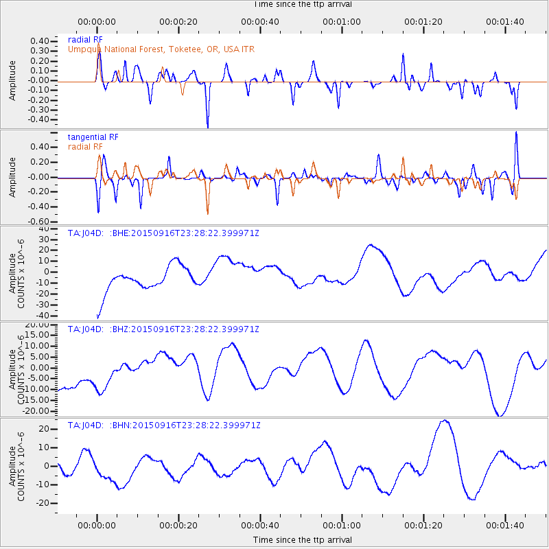
J04D Umpqua National Forest, Toketee, OR, USA - Earthquake Result Viewer
*The percent match for this event was below the threshold and hence no stack was calculated.
| Earthquake location: |
Near Coast Of Central Chile |
| Earthquake latitude/longitude: |
-31.6/-71.9 |
| Earthquake time(UTC): |
2015/09/16 (259) 23:16:05 GMT |
| Earthquake Depth: |
10 km |
| Earthquake Magnitude: |
6.2 MB |
| Earthquake Catalog/Contributor: |
NEIC PDE/NEIC COMCAT |
|
| Network: |
TA USArray Transportable Network (new EarthScope stations) |
| Station: |
J04D Umpqua National Forest, Toketee, OR, USA |
| Lat/Lon: |
43.24 N/122.11 W |
| Elevation: |
1948 m |
|
| Distance: |
87.5 deg |
| Az: |
325.808 deg |
| Baz: |
138.984 deg |
| Ray Param: |
$rayparam |
*The percent match for this event was below the threshold and hence was not used in the summary stack. |
|
| Radial Match: |
49.118114 % |
| Radial Bump: |
244 |
| Transverse Match: |
38.607628 % |
| Transverse Bump: |
352 |
| SOD ConfigId: |
7422571 |
| Insert Time: |
2019-04-20 19:43:06.099 +0000 |
| GWidth: |
2.5 |
| Max Bumps: |
400 |
| Tol: |
0.001 |
|
Signal To Noise
| Channel | StoN | STA | LTA |
| TA:J04D: :BHZ:20150916T23:28:22.399971Z | 1.0660095 | 1.1060299E-5 | 1.0375422E-5 |
| TA:J04D: :BHN:20150916T23:28:22.399971Z | 0.72815967 | 7.1148243E-6 | 9.770967E-6 |
| TA:J04D: :BHE:20150916T23:28:22.399971Z | 1.644314 | 1.8922387E-5 | 1.1507769E-5 |
| Arrivals |
| Ps | |
| PpPs | |
| PsPs/PpSs | |


