You are here: Home > Network List > TA - USArray Transportable Network (new EarthScope stations) Stations List
> Station W41B Gary Mavity, Velonia, AR, USA > Earthquake Result Viewer
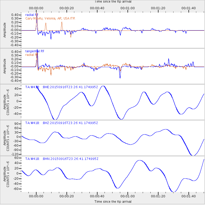
W41B Gary Mavity, Velonia, AR, USA - Earthquake Result Viewer
*The percent match for this event was below the threshold and hence no stack was calculated.
| Earthquake location: |
Near Coast Of Central Chile |
| Earthquake latitude/longitude: |
-31.6/-71.9 |
| Earthquake time(UTC): |
2015/09/16 (259) 23:16:05 GMT |
| Earthquake Depth: |
10 km |
| Earthquake Magnitude: |
6.2 MB |
| Earthquake Catalog/Contributor: |
NEIC PDE/NEIC COMCAT |
|
| Network: |
TA USArray Transportable Network (new EarthScope stations) |
| Station: |
W41B Gary Mavity, Velonia, AR, USA |
| Lat/Lon: |
35.17 N/92.25 W |
| Elevation: |
95 m |
|
| Distance: |
69.1 deg |
| Az: |
342.255 deg |
| Baz: |
161.489 deg |
| Ray Param: |
$rayparam |
*The percent match for this event was below the threshold and hence was not used in the summary stack. |
|
| Radial Match: |
61.22936 % |
| Radial Bump: |
293 |
| Transverse Match: |
65.90485 % |
| Transverse Bump: |
282 |
| SOD ConfigId: |
7422571 |
| Insert Time: |
2019-04-20 19:43:21.238 +0000 |
| GWidth: |
2.5 |
| Max Bumps: |
400 |
| Tol: |
0.001 |
|
Signal To Noise
| Channel | StoN | STA | LTA |
| TA:W41B: :BHZ:20150916T23:26:41.174995Z | 3.1179757 | 4.2195457E-5 | 1.3532965E-5 |
| TA:W41B: :BHN:20150916T23:26:41.174995Z | 0.3986057 | 1.2259765E-5 | 3.0756622E-5 |
| TA:W41B: :BHE:20150916T23:26:41.174995Z | 1.042298 | 3.1385196E-5 | 3.0111541E-5 |
| Arrivals |
| Ps | |
| PpPs | |
| PsPs/PpSs | |


