You are here: Home > Network List > IU - Global Seismograph Network (GSN - IRIS/USGS) Stations List
> Station TUC Tucson, Arizona > Earthquake Result Viewer
TUC Tucson, Arizona - Earthquake Result Viewer

| Earthquake location: |
Near East Coast Of Kamchatka |
| Earthquake latitude/longitude: |
51.9/158.7 |
| Earthquake time(UTC): |
1993/11/13 (317) 01:18:04 GMT |
| Earthquake Depth: |
34 km |
| Earthquake Magnitude: |
6.5 MB, 7.1 MS, 6.9 UNKNOWN |
| Earthquake Catalog/Contributor: |
WHDF/NEIC |
|
| Network: |
IU Global Seismograph Network (GSN - IRIS/USGS) |
| Station: |
TUC Tucson, Arizona |
| Lat/Lon: |
32.31 N/110.78 W |
| Elevation: |
874 m |
|
| Distance: |
65.6 deg |
| Az: |
68.393 deg |
| Baz: |
317.156 deg |
| Ray Param: |
0.0581038 |
| Estimated Moho Depth: |
19.75 km |
| Estimated Crust Vp/Vs: |
1.77 |
| Assumed Crust Vp: |
6.276 km/s |
| Estimated Crust Vs: |
3.541 km/s |
| Estimated Crust Poisson's Ratio: |
0.27 |
|
| Radial Match: |
95.46635 % |
| Radial Bump: |
329 |
| Transverse Match: |
79.28197 % |
| Transverse Bump: |
400 |
| SOD ConfigId: |
16938 |
| Insert Time: |
2010-03-04 19:43:35.240 +0000 |
| GWidth: |
2.5 |
| Max Bumps: |
400 |
| Tol: |
0.001 |
|
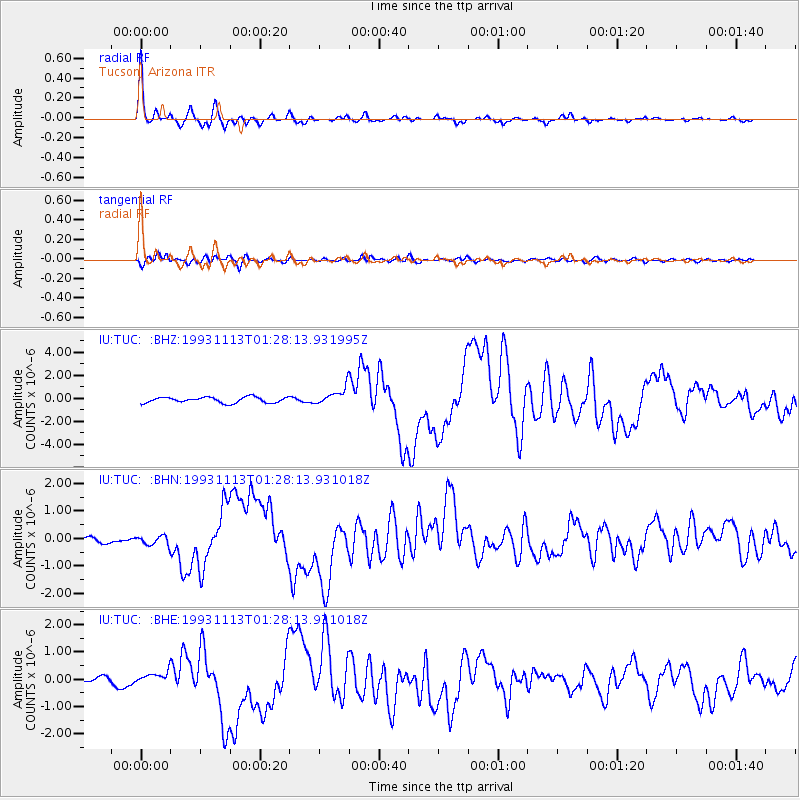
Signal To Noise
| Channel | StoN | STA | LTA |
| IU:TUC: :BHN:19931113T01:28:13.931018Z | 1.4081813 | 1.6652281E-7 | 1.1825381E-7 |
| IU:TUC: :BHE:19931113T01:28:13.931018Z | 1.7999867 | 2.3215004E-7 | 1.289732E-7 |
| IU:TUC: :BHZ:19931113T01:28:13.931995Z | 2.9907117 | 7.2818665E-7 | 2.4348273E-7 |
| Arrivals |
| Ps | 2.5 SECOND |
| PpPs | 8.4 SECOND |
| PsPs/PpSs | 11 SECOND |


