You are here: Home > Network List > CI - Caltech Regional Seismic Network Stations List
> Station BAR Barrett, Tecate, CA, USA > Earthquake Result Viewer
BAR Barrett, Tecate, CA, USA - Earthquake Result Viewer
| Earthquake location: |
Near Coast Of Central Chile |
| Earthquake latitude/longitude: |
-31.6/-71.4 |
| Earthquake time(UTC): |
2015/09/16 (259) 23:18:42 GMT |
| Earthquake Depth: |
31 km |
| Earthquake Magnitude: |
6.4 MB |
| Earthquake Catalog/Contributor: |
NEIC PDE/NEIC COMCAT |
|
| Network: |
CI Caltech Regional Seismic Network |
| Station: |
BAR Barrett, Tecate, CA, USA |
| Lat/Lon: |
32.68 N/116.67 W |
| Elevation: |
521 m |
|
| Distance: |
76.9 deg |
| Az: |
322.056 deg |
| Baz: |
141.52 deg |
| Ray Param: |
0.050639935 |
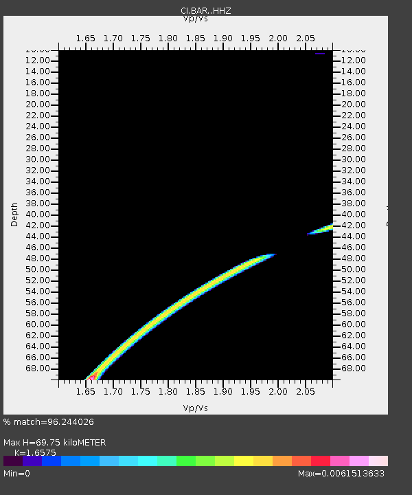
| Estimated Moho Depth: |
69.75 km |
| Estimated Crust Vp/Vs: |
1.66 |
| Assumed Crust Vp: |
6.264 km/s |
| Estimated Crust Vs: |
3.779 km/s |
| Estimated Crust Poisson's Ratio: |
0.21 |
|
| Radial Match: |
96.244026 % |
| Radial Bump: |
188 |
| Transverse Match: |
81.311035 % |
| Transverse Bump: |
263 |
| SOD ConfigId: |
7422571 |
| Insert Time: |
2019-04-20 19:46:59.404 +0000 |
| GWidth: |
2.5 |
| Max Bumps: |
400 |
| Tol: |
0.001 |
|
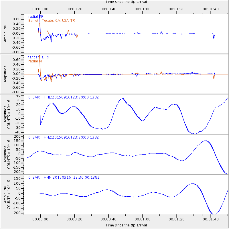
Signal To Noise
| Channel | StoN | STA | LTA |
| CI:BAR: :HHZ:20150916T23:30:00.138Z | 2.5407073 | 4.5105502E-5 | 1.7753127E-5 |
| CI:BAR: :HHN:20150916T23:30:00.138Z | 0.7271257 | 6.5964728E-6 | 9.071984E-6 |
| CI:BAR: :HHE:20150916T23:30:00.138Z | 4.155939 | 3.9368522E-5 | 9.472834E-6 |
| Arrivals |
| Ps | 7.6 SECOND |
| PpPs | 29 SECOND |
| PsPs/PpSs | 36 SECOND |


