You are here: Home > Network List > CI - Caltech Regional Seismic Network Stations List
> Station SWS Sam W. Stewart, Westmorland, CA, USA > Earthquake Result Viewer
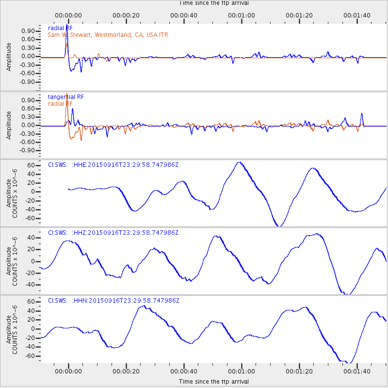
SWS Sam W. Stewart, Westmorland, CA, USA - Earthquake Result Viewer
*The percent match for this event was below the threshold and hence no stack was calculated.
| Earthquake location: |
Near Coast Of Central Chile |
| Earthquake latitude/longitude: |
-31.6/-71.4 |
| Earthquake time(UTC): |
2015/09/16 (259) 23:18:42 GMT |
| Earthquake Depth: |
31 km |
| Earthquake Magnitude: |
6.4 MB |
| Earthquake Catalog/Contributor: |
NEIC PDE/NEIC COMCAT |
|
| Network: |
CI Caltech Regional Seismic Network |
| Station: |
SWS Sam W. Stewart, Westmorland, CA, USA |
| Lat/Lon: |
32.94 N/115.80 W |
| Elevation: |
140 m |
|
| Distance: |
76.7 deg |
| Az: |
322.817 deg |
| Baz: |
142.167 deg |
| Ray Param: |
$rayparam |
*The percent match for this event was below the threshold and hence was not used in the summary stack. |
|
| Radial Match: |
79.83979 % |
| Radial Bump: |
318 |
| Transverse Match: |
84.292564 % |
| Transverse Bump: |
204 |
| SOD ConfigId: |
7422571 |
| Insert Time: |
2019-04-20 19:47:24.444 +0000 |
| GWidth: |
2.5 |
| Max Bumps: |
400 |
| Tol: |
0.001 |
|
Signal To Noise
| Channel | StoN | STA | LTA |
| CI:SWS: :HHZ:20150916T23:29:58.747986Z | 7.671641 | 4.2236476E-5 | 5.5055334E-6 |
| CI:SWS: :HHN:20150916T23:29:58.747986Z | 0.198577 | 3.1660338E-6 | 1.5943608E-5 |
| CI:SWS: :HHE:20150916T23:29:58.747986Z | 0.20661439 | 3.7902905E-6 | 1.8344756E-5 |
| Arrivals |
| Ps | |
| PpPs | |
| PsPs/PpSs | |


