You are here: Home > Network List > TA - USArray Transportable Network (new EarthScope stations) Stations List
> Station O03E Paynes Creek, CA, USA > Earthquake Result Viewer
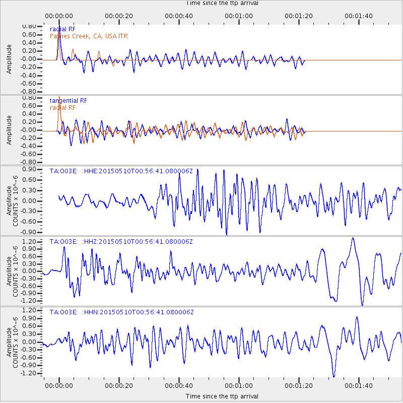
O03E Paynes Creek, CA, USA - Earthquake Result Viewer
*The percent match for this event was below the threshold and hence no stack was calculated.
| Earthquake location: |
Near Coast Of Chiapas, Mexico |
| Earthquake latitude/longitude: |
14.9/-94.0 |
| Earthquake time(UTC): |
2015/05/10 (130) 00:50:18 GMT |
| Earthquake Depth: |
6.7 km |
| Earthquake Magnitude: |
5.6 MB |
| Earthquake Catalog/Contributor: |
NEIC PDE/NEIC COMCAT |
|
| Network: |
TA USArray Transportable Network (new EarthScope stations) |
| Station: |
O03E Paynes Creek, CA, USA |
| Lat/Lon: |
40.29 N/121.80 W |
| Elevation: |
967 m |
|
| Distance: |
35.1 deg |
| Az: |
321.611 deg |
| Baz: |
128.272 deg |
| Ray Param: |
$rayparam |
*The percent match for this event was below the threshold and hence was not used in the summary stack. |
|
| Radial Match: |
74.21389 % |
| Radial Bump: |
400 |
| Transverse Match: |
62.503853 % |
| Transverse Bump: |
400 |
| SOD ConfigId: |
976571 |
| Insert Time: |
2015-05-24 01:31:39.790 +0000 |
| GWidth: |
2.5 |
| Max Bumps: |
400 |
| Tol: |
0.001 |
|
Signal To Noise
| Channel | StoN | STA | LTA |
| TA:O03E: :HHZ:20150510T00:56:41.080006Z | 7.7653437 | 4.632456E-7 | 5.965552E-8 |
| TA:O03E: :HHN:20150510T00:56:41.080006Z | 1.7023777 | 1.7026727E-7 | 1.0001734E-7 |
| TA:O03E: :HHE:20150510T00:56:41.080006Z | 2.428497 | 2.5927292E-7 | 1.06762705E-7 |
| Arrivals |
| Ps | |
| PpPs | |
| PsPs/PpSs | |


