You are here: Home > Network List > TA - USArray Transportable Network (new EarthScope stations) Stations List
> Station A21K Barrow, AK, USA > Earthquake Result Viewer
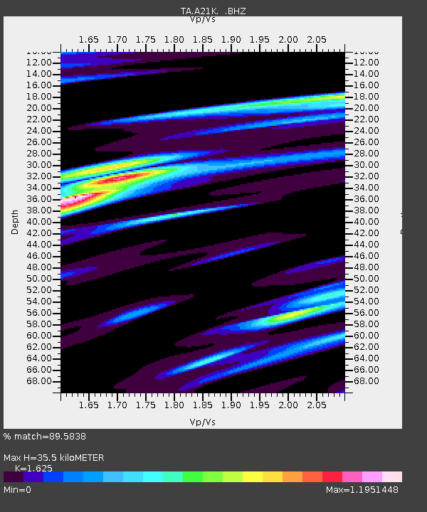
A21K Barrow, AK, USA - Earthquake Result Viewer
| Earthquake location: |
Near Coast Of Chiapas, Mexico |
| Earthquake latitude/longitude: |
14.9/-94.0 |
| Earthquake time(UTC): |
2015/05/10 (130) 00:50:18 GMT |
| Earthquake Depth: |
6.7 km |
| Earthquake Magnitude: |
5.6 MB |
| Earthquake Catalog/Contributor: |
NEIC PDE/NEIC COMCAT |
|
| Network: |
TA USArray Transportable Network (new EarthScope stations) |
| Station: |
A21K Barrow, AK, USA |
| Lat/Lon: |
71.32 N/156.62 W |
| Elevation: |
577 m |
|
| Distance: |
67.4 deg |
| Az: |
341.944 deg |
| Baz: |
111.528 deg |
| Ray Param: |
0.057000127 |
| Estimated Moho Depth: |
35.5 km |
| Estimated Crust Vp/Vs: |
1.62 |
| Assumed Crust Vp: |
6.048 km/s |
| Estimated Crust Vs: |
3.722 km/s |
| Estimated Crust Poisson's Ratio: |
0.20 |
|
| Radial Match: |
89.5838 % |
| Radial Bump: |
400 |
| Transverse Match: |
74.833565 % |
| Transverse Bump: |
400 |
| SOD ConfigId: |
976571 |
| Insert Time: |
2015-05-24 01:32:20.703 +0000 |
| GWidth: |
2.5 |
| Max Bumps: |
400 |
| Tol: |
0.001 |
|

Signal To Noise
| Channel | StoN | STA | LTA |
| TA:A21K: :BHZ:20150510T01:00:42.925007Z | 8.469736 | 6.913171E-7 | 8.162204E-8 |
| TA:A21K: :BHN:20150510T01:00:42.925007Z | 2.3334665 | 2.2702285E-7 | 9.7289956E-8 |
| TA:A21K: :BHE:20150510T01:00:42.925007Z | 4.506516 | 3.1821003E-7 | 7.061109E-8 |
| Arrivals |
| Ps | 3.8 SECOND |
| PpPs | 15 SECOND |
| PsPs/PpSs | 19 SECOND |


