You are here: Home > Network List > TA - USArray Transportable Network (new EarthScope stations) Stations List
> Station J04D Umpqua National Forest, Toketee, OR, USA > Earthquake Result Viewer
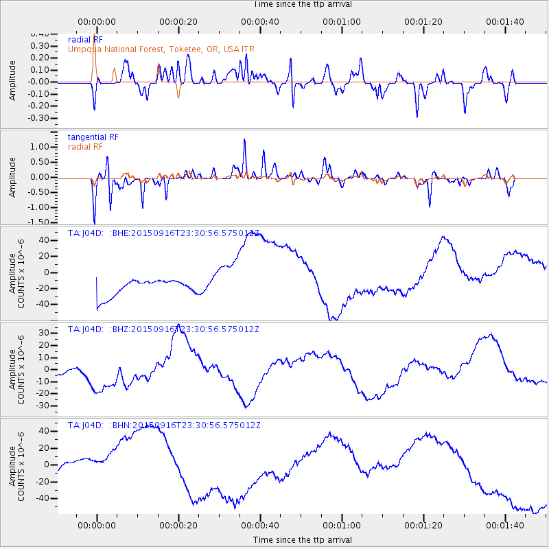
J04D Umpqua National Forest, Toketee, OR, USA - Earthquake Result Viewer
*The percent match for this event was below the threshold and hence no stack was calculated.
| Earthquake location: |
Near Coast Of Central Chile |
| Earthquake latitude/longitude: |
-31.6/-71.4 |
| Earthquake time(UTC): |
2015/09/16 (259) 23:18:42 GMT |
| Earthquake Depth: |
31 km |
| Earthquake Magnitude: |
6.4 MB |
| Earthquake Catalog/Contributor: |
NEIC PDE/NEIC COMCAT |
|
| Network: |
TA USArray Transportable Network (new EarthScope stations) |
| Station: |
J04D Umpqua National Forest, Toketee, OR, USA |
| Lat/Lon: |
43.24 N/122.11 W |
| Elevation: |
1948 m |
|
| Distance: |
87.7 deg |
| Az: |
325.541 deg |
| Baz: |
138.642 deg |
| Ray Param: |
$rayparam |
*The percent match for this event was below the threshold and hence was not used in the summary stack. |
|
| Radial Match: |
55.164326 % |
| Radial Bump: |
400 |
| Transverse Match: |
74.682106 % |
| Transverse Bump: |
302 |
| SOD ConfigId: |
7422571 |
| Insert Time: |
2019-04-20 19:51:06.225 +0000 |
| GWidth: |
2.5 |
| Max Bumps: |
400 |
| Tol: |
0.001 |
|
Signal To Noise
| Channel | StoN | STA | LTA |
| TA:J04D: :BHZ:20150916T23:30:56.575012Z | 3.9612818 | 1.8952987E-5 | 4.784559E-6 |
| TA:J04D: :BHN:20150916T23:30:56.575012Z | 1.8991543 | 2.9729217E-5 | 1.5653924E-5 |
| TA:J04D: :BHE:20150916T23:30:56.575012Z | 3.1787598 | 3.0603544E-5 | 9.627511E-6 |
| Arrivals |
| Ps | |
| PpPs | |
| PsPs/PpSs | |


