You are here: Home > Network List > TA - USArray Transportable Network (new EarthScope stations) Stations List
> Station Q61A Milford, DE, USA > Earthquake Result Viewer
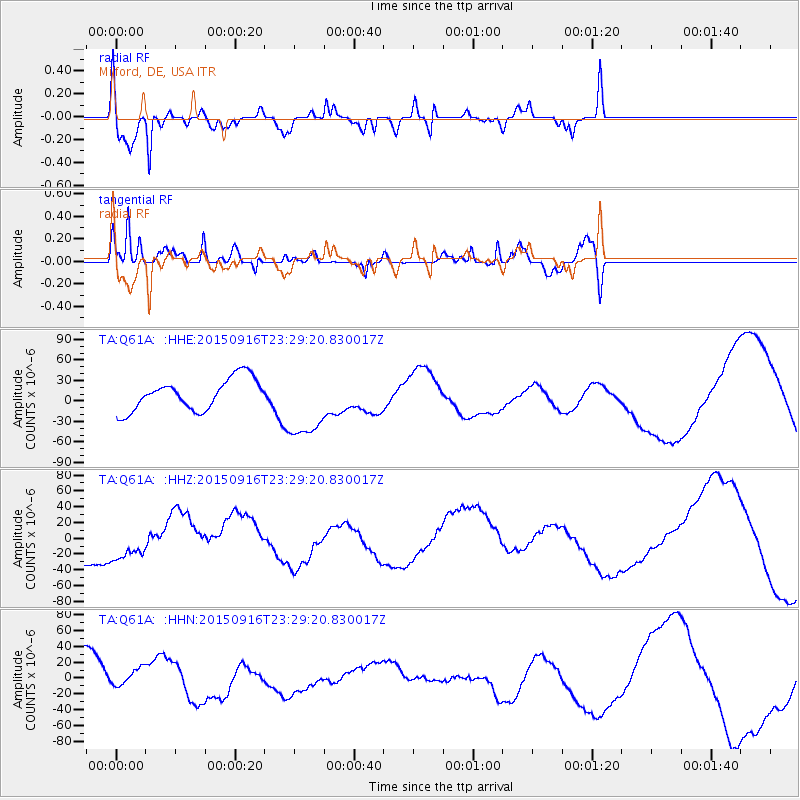
Q61A Milford, DE, USA - Earthquake Result Viewer
*The percent match for this event was below the threshold and hence no stack was calculated.
| Earthquake location: |
Near Coast Of Central Chile |
| Earthquake latitude/longitude: |
-31.6/-71.4 |
| Earthquake time(UTC): |
2015/09/16 (259) 23:18:42 GMT |
| Earthquake Depth: |
31 km |
| Earthquake Magnitude: |
6.4 MB |
| Earthquake Catalog/Contributor: |
NEIC PDE/NEIC COMCAT |
|
| Network: |
TA USArray Transportable Network (new EarthScope stations) |
| Station: |
Q61A Milford, DE, USA |
| Lat/Lon: |
38.88 N/75.33 W |
| Elevation: |
5.0 m |
|
| Distance: |
70.2 deg |
| Az: |
356.765 deg |
| Baz: |
176.462 deg |
| Ray Param: |
$rayparam |
*The percent match for this event was below the threshold and hence was not used in the summary stack. |
|
| Radial Match: |
72.92534 % |
| Radial Bump: |
400 |
| Transverse Match: |
38.120266 % |
| Transverse Bump: |
323 |
| SOD ConfigId: |
7422571 |
| Insert Time: |
2019-04-20 19:51:16.900 +0000 |
| GWidth: |
2.5 |
| Max Bumps: |
400 |
| Tol: |
0.001 |
|
Signal To Noise
| Channel | StoN | STA | LTA |
| TA:Q61A: :HHZ:20150916T23:29:20.830017Z | 0.79370606 | 3.5031644E-5 | 4.41368E-5 |
| TA:Q61A: :HHN:20150916T23:29:20.830017Z | 0.6027302 | 1.7749233E-5 | 2.9448056E-5 |
| TA:Q61A: :HHE:20150916T23:29:20.830017Z | 2.2787507 | 5.1041887E-5 | 2.2399066E-5 |
| Arrivals |
| Ps | |
| PpPs | |
| PsPs/PpSs | |


