You are here: Home > Network List > UW - Pacific Northwest Regional Seismic Network Stations List
> Station HOOD Mt Hood Meadows, OR CREST BB SMO > Earthquake Result Viewer
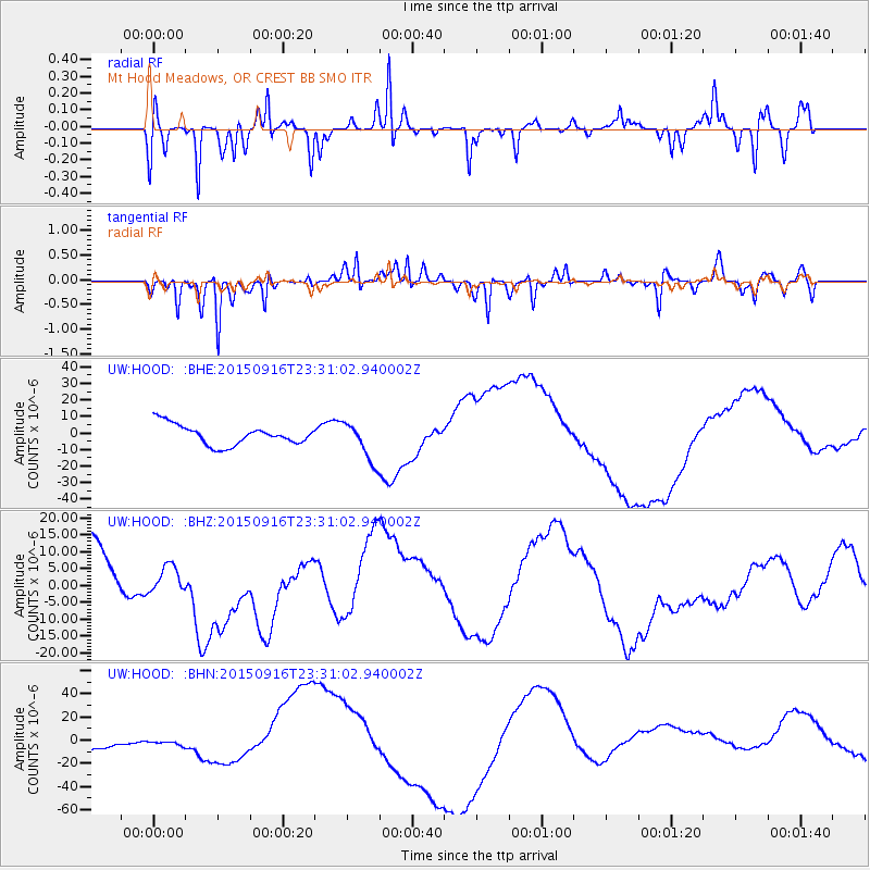
HOOD Mt Hood Meadows, OR CREST BB SMO - Earthquake Result Viewer
*The percent match for this event was below the threshold and hence no stack was calculated.
| Earthquake location: |
Near Coast Of Central Chile |
| Earthquake latitude/longitude: |
-31.6/-71.4 |
| Earthquake time(UTC): |
2015/09/16 (259) 23:18:42 GMT |
| Earthquake Depth: |
31 km |
| Earthquake Magnitude: |
6.4 MB |
| Earthquake Catalog/Contributor: |
NEIC PDE/NEIC COMCAT |
|
| Network: |
UW Pacific Northwest Regional Seismic Network |
| Station: |
HOOD Mt Hood Meadows, OR CREST BB SMO |
| Lat/Lon: |
45.32 N/121.65 W |
| Elevation: |
1520 m |
|
| Distance: |
89.1 deg |
| Az: |
327.158 deg |
| Baz: |
139.003 deg |
| Ray Param: |
$rayparam |
*The percent match for this event was below the threshold and hence was not used in the summary stack. |
|
| Radial Match: |
76.8044 % |
| Radial Bump: |
391 |
| Transverse Match: |
82.632645 % |
| Transverse Bump: |
400 |
| SOD ConfigId: |
7422571 |
| Insert Time: |
2019-04-20 19:51:53.963 +0000 |
| GWidth: |
2.5 |
| Max Bumps: |
400 |
| Tol: |
0.001 |
|
Signal To Noise
| Channel | StoN | STA | LTA |
| UW:HOOD: :BHZ:20150916T23:31:02.940002Z | 0.31317964 | 3.4304367E-6 | 1.0953574E-5 |
| UW:HOOD: :BHN:20150916T23:31:02.940002Z | 0.25586236 | 2.1958535E-6 | 8.5821675E-6 |
| UW:HOOD: :BHE:20150916T23:31:02.940002Z | 2.241772 | 1.3167533E-5 | 5.8737173E-6 |
| Arrivals |
| Ps | |
| PpPs | |
| PsPs/PpSs | |


