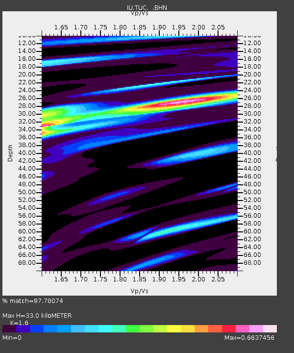
TUC Tucson, Arizona - Earthquake Result Viewer
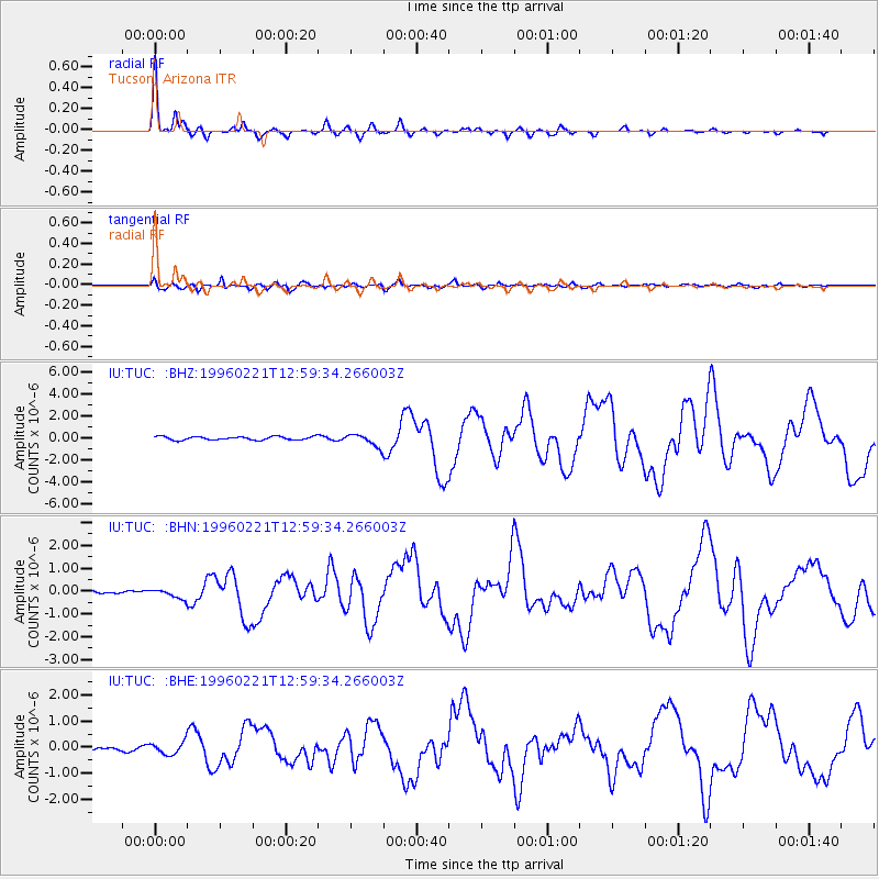
Earthquake location: Off Coast Of Northern Peru
Earthquake latitude/longitude: -9.6/-79.6
Earthquake time(UTC): 1996/02/21 (052) 12:51:04 GMT
Earthquake Depth: 33 km
Earthquake Magnitude: 5.8 MB, 6.6 MS, 7.5 UNKNOWN, 7.3 MW
Earthquake Catalog/Contributor: WHDF/NEIC
Network: IU Global Seismograph Network (GSN - IRIS/USGS)
Station: TUC Tucson, Arizona
Lat/Lon: 32.31 N/110.78 W
Elevation: 874 m
Distance: 51.3 deg
Az: 325.759 deg
Baz: 139.061 deg
Ray Param: 0.0674673
Estimated Moho Depth: 33.0 km
Estimated Crust Vp/Vs: 1.60
Assumed Crust Vp: 6.276 km/s
Estimated Crust Vs: 3.922 km/s
Estimated Crust Poisson's Ratio: 0.18
Radial Match: 97.78074 %
Radial Bump: 302
Transverse Match: 83.2441 %
Transverse Bump: 400
SOD ConfigId: 6273
Insert Time: 2010-03-04 19:45:18.315 +0000
GWidth: 2.5
Max Bumps: 400
Tol: 0.001

Signal To Noise

ChannelStoNSTALTA
IU:TUC: :BHN:19960221T12:59:34.266003Z1.42448222.0173566E-71.4162035E-7
IU:TUC: :BHE:19960221T12:59:34.266003Z1.50637382.3837153E-71.5824195E-7
IU:TUC: :BHZ:19960221T12:59:34.266003Z3.64503155.6021696E-71.536933E-7
Arrivals
Ps3.3 SECOND
PpPs13 SECOND
PsPs/PpSs16 SECOND