You are here: Home > Network List > US - United States National Seismic Network Stations List
> Station EGMT Eagleton, Montana, USA > Earthquake Result Viewer
EGMT Eagleton, Montana, USA - Earthquake Result Viewer
| Earthquake location: |
Near Coast Of Chiapas, Mexico |
| Earthquake latitude/longitude: |
14.9/-94.0 |
| Earthquake time(UTC): |
2015/05/10 (130) 00:50:18 GMT |
| Earthquake Depth: |
6.7 km |
| Earthquake Magnitude: |
5.6 MB |
| Earthquake Catalog/Contributor: |
NEIC PDE/NEIC COMCAT |
|
| Network: |
US United States National Seismic Network |
| Station: |
EGMT Eagleton, Montana, USA |
| Lat/Lon: |
48.02 N/109.75 W |
| Elevation: |
1055 m |
|
| Distance: |
35.5 deg |
| Az: |
341.716 deg |
| Baz: |
153.134 deg |
| Ray Param: |
0.07717433 |
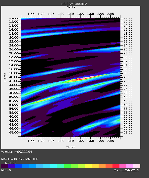
| Estimated Moho Depth: |
39.75 km |
| Estimated Crust Vp/Vs: |
1.94 |
| Assumed Crust Vp: |
6.438 km/s |
| Estimated Crust Vs: |
3.318 km/s |
| Estimated Crust Poisson's Ratio: |
0.32 |
|
| Radial Match: |
90.11104 % |
| Radial Bump: |
296 |
| Transverse Match: |
62.3445 % |
| Transverse Bump: |
400 |
| SOD ConfigId: |
976571 |
| Insert Time: |
2015-05-24 01:34:20.861 +0000 |
| GWidth: |
2.5 |
| Max Bumps: |
400 |
| Tol: |
0.001 |
|
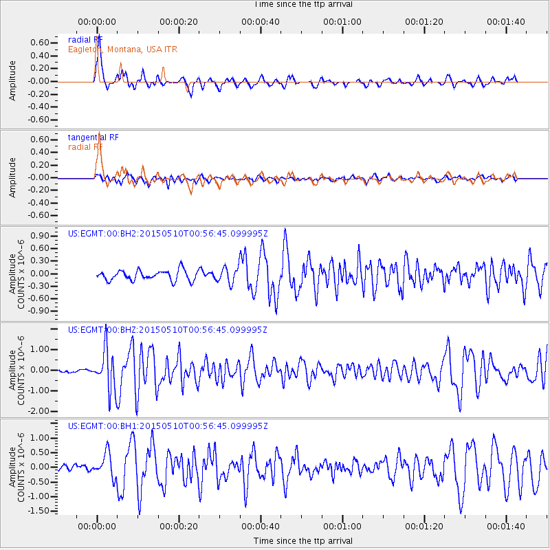
Signal To Noise
| Channel | StoN | STA | LTA |
| US:EGMT:00:BHZ:20150510T00:56:45.099995Z | 11.563037 | 1.0129866E-6 | 8.760558E-8 |
| US:EGMT:00:BH1:20150510T00:56:45.099995Z | 2.5569353 | 4.1660772E-7 | 1.6293244E-7 |
| US:EGMT:00:BH2:20150510T00:56:45.099995Z | 1.5845168 | 1.9006926E-7 | 1.1995408E-7 |
| Arrivals |
| Ps | 6.2 SECOND |
| PpPs | 17 SECOND |
| PsPs/PpSs | 23 SECOND |


