You are here: Home > Network List > TA - USArray Transportable Network (new EarthScope stations) Stations List
> Station SFIN Lafayette, IN, USA > Earthquake Result Viewer
SFIN Lafayette, IN, USA - Earthquake Result Viewer
| Earthquake location: |
Near Coast Of Central Chile |
| Earthquake latitude/longitude: |
-31.2/-71.8 |
| Earthquake time(UTC): |
2015/09/16 (259) 23:23:26 GMT |
| Earthquake Depth: |
37 km |
| Earthquake Magnitude: |
5.6 MB |
| Earthquake Catalog/Contributor: |
NEIC PDE/NEIC COMCAT |
|
| Network: |
TA USArray Transportable Network (new EarthScope stations) |
| Station: |
SFIN Lafayette, IN, USA |
| Lat/Lon: |
40.38 N/87.10 W |
| Elevation: |
165 m |
|
| Distance: |
72.6 deg |
| Az: |
347.789 deg |
| Baz: |
166.27 deg |
| Ray Param: |
0.053504113 |
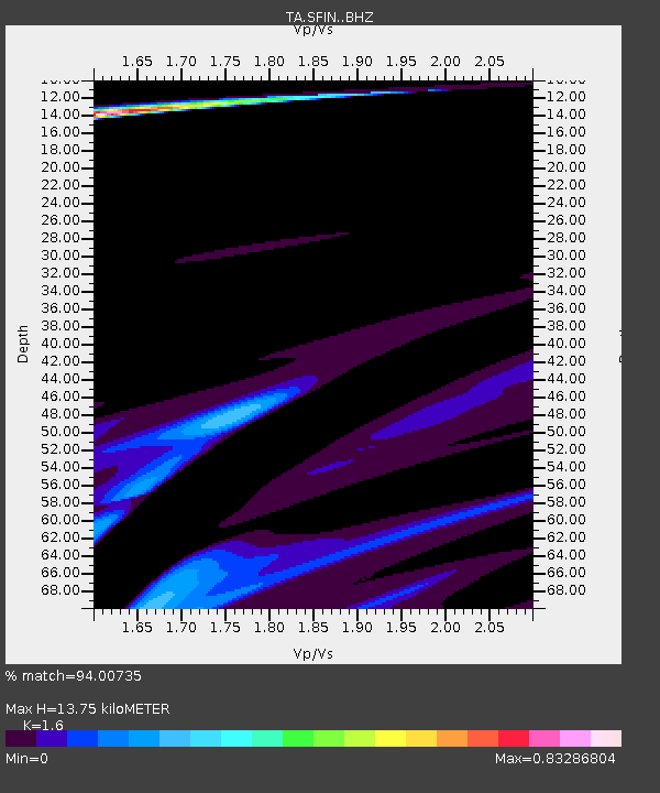
| Estimated Moho Depth: |
13.75 km |
| Estimated Crust Vp/Vs: |
1.60 |
| Assumed Crust Vp: |
6.498 km/s |
| Estimated Crust Vs: |
4.061 km/s |
| Estimated Crust Poisson's Ratio: |
0.18 |
|
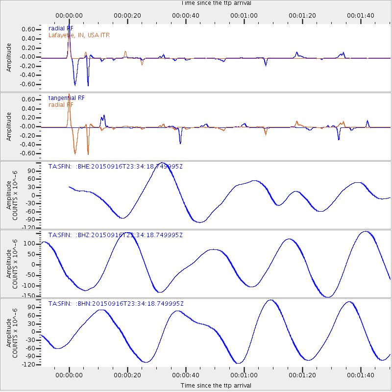
| Radial Match: |
94.00735 % |
| Radial Bump: |
400 |
| Transverse Match: |
46.93368 % |
| Transverse Bump: |
155 |
| SOD ConfigId: |
7422571 |
| Insert Time: |
2019-04-20 19:58:06.733 +0000 |
| GWidth: |
2.5 |
| Max Bumps: |
400 |
| Tol: |
0.001 |
|
Signal To Noise
| Channel | StoN | STA | LTA |
| TA:SFIN: :BHZ:20150916T23:34:18.749995Z | 1.9976767 | 1.05630104E-4 | 5.287648E-5 |
| TA:SFIN: :BHN:20150916T23:34:18.749995Z | 0.96364516 | 2.5362548E-5 | 2.6319385E-5 |
| TA:SFIN: :BHE:20150916T23:34:18.749995Z | 3.527346 | 1.3258602E-4 | 3.758804E-5 |
| Arrivals |
| Ps | 1.3 SECOND |
| PpPs | 5.3 SECOND |
| PsPs/PpSs | 6.6 SECOND |


