You are here: Home > Network List > TA - USArray Transportable Network (new EarthScope stations) Stations List
> Station TUL1 Leonard, OK, USA > Earthquake Result Viewer
TUL1 Leonard, OK, USA - Earthquake Result Viewer
| Earthquake location: |
Near Coast Of Central Chile |
| Earthquake latitude/longitude: |
-31.2/-71.8 |
| Earthquake time(UTC): |
2015/09/16 (259) 23:23:26 GMT |
| Earthquake Depth: |
37 km |
| Earthquake Magnitude: |
5.6 MB |
| Earthquake Catalog/Contributor: |
NEIC PDE/NEIC COMCAT |
|
| Network: |
TA USArray Transportable Network (new EarthScope stations) |
| Station: |
TUL1 Leonard, OK, USA |
| Lat/Lon: |
35.91 N/95.79 W |
| Elevation: |
256 m |
|
| Distance: |
70.4 deg |
| Az: |
339.474 deg |
| Baz: |
158.27 deg |
| Ray Param: |
0.054927077 |
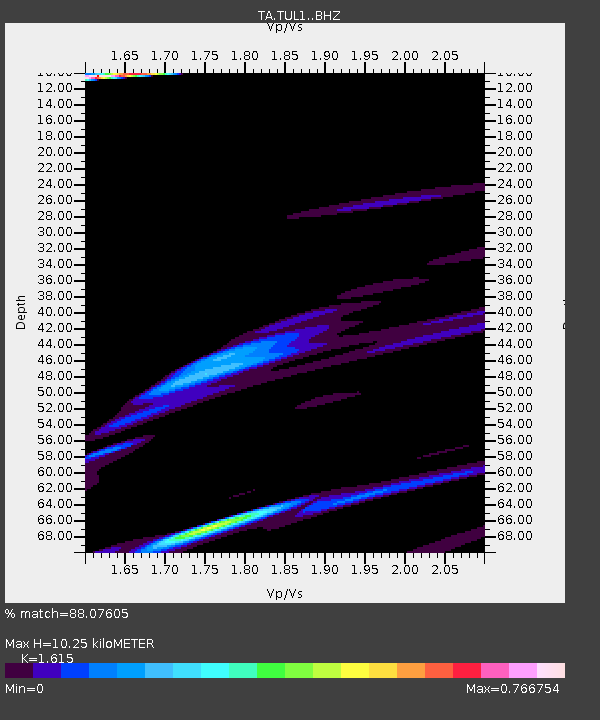
| Estimated Moho Depth: |
10.25 km |
| Estimated Crust Vp/Vs: |
1.62 |
| Assumed Crust Vp: |
6.498 km/s |
| Estimated Crust Vs: |
4.023 km/s |
| Estimated Crust Poisson's Ratio: |
0.19 |
|
| Radial Match: |
88.07605 % |
| Radial Bump: |
400 |
| Transverse Match: |
83.611084 % |
| Transverse Bump: |
357 |
| SOD ConfigId: |
7422571 |
| Insert Time: |
2019-04-20 19:58:07.865 +0000 |
| GWidth: |
2.5 |
| Max Bumps: |
400 |
| Tol: |
0.001 |
|

Signal To Noise
| Channel | StoN | STA | LTA |
| TA:TUL1: :BHZ:20150916T23:34:05.799983Z | 1.0319525 | 7.4077114E-5 | 7.1783455E-5 |
| TA:TUL1: :BHN:20150916T23:34:05.799983Z | 0.5829487 | 3.8858765E-5 | 6.6658984E-5 |
| TA:TUL1: :BHE:20150916T23:34:05.799983Z | 1.6437197 | 5.2737745E-5 | 3.208439E-5 |
| Arrivals |
| Ps | 1.0 SECOND |
| PpPs | 4.0 SECOND |
| PsPs/PpSs | 5.0 SECOND |


