You are here: Home > Network List > IU - Global Seismograph Network (GSN - IRIS/USGS) Stations List
> Station TUC Tucson, Arizona > Earthquake Result Viewer
TUC Tucson, Arizona - Earthquake Result Viewer
| Earthquake location: |
Tonga Islands |
| Earthquake latitude/longitude: |
-19.9/-173.3 |
| Earthquake time(UTC): |
1997/02/07 (038) 08:41:13 GMT |
| Earthquake Depth: |
28 km |
| Earthquake Magnitude: |
6.0 MB, 6.2 MS, 6.4 UNKNOWN, 6.0 ME |
| Earthquake Catalog/Contributor: |
WHDF/NEIC |
|
| Network: |
IU Global Seismograph Network (GSN - IRIS/USGS) |
| Station: |
TUC Tucson, Arizona |
| Lat/Lon: |
32.31 N/110.78 W |
| Elevation: |
874 m |
|
| Distance: |
79.1 deg |
| Az: |
49.892 deg |
| Baz: |
238.228 deg |
| Ray Param: |
0.04912757 |
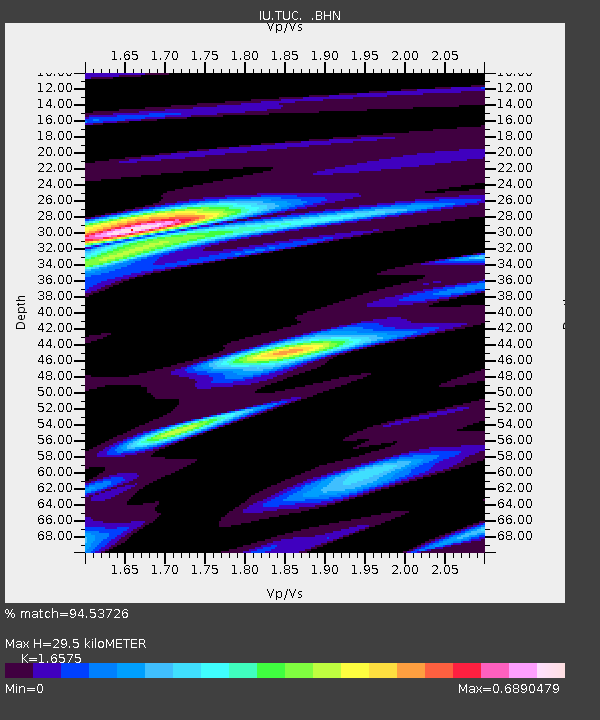
| Estimated Moho Depth: |
29.5 km |
| Estimated Crust Vp/Vs: |
1.66 |
| Assumed Crust Vp: |
6.276 km/s |
| Estimated Crust Vs: |
3.786 km/s |
| Estimated Crust Poisson's Ratio: |
0.21 |
|
| Radial Match: |
94.53726 % |
| Radial Bump: |
397 |
| Transverse Match: |
75.04478 % |
| Transverse Bump: |
400 |
| SOD ConfigId: |
6273 |
| Insert Time: |
2010-03-04 19:45:38.191 +0000 |
| GWidth: |
2.5 |
| Max Bumps: |
400 |
| Tol: |
0.001 |
|

Signal To Noise
| Channel | StoN | STA | LTA |
| IU:TUC: :BHN:19970207T08:52:44.241003Z | 2.9669697 | 3.4768746E-7 | 1.1718604E-7 |
| IU:TUC: :BHE:19970207T08:52:44.241003Z | 5.8359804 | 6.537078E-7 | 1.1201337E-7 |
| IU:TUC: :BHZ:19970207T08:52:44.241003Z | 15.338409 | 1.7285996E-6 | 1.1269745E-7 |
| Arrivals |
| Ps | 3.2 SECOND |
| PpPs | 12 SECOND |
| PsPs/PpSs | 15 SECOND |


