You are here: Home > Network List > CN - Canadian National Seismograph Network Stations List
> Station VIMO VICTOR MINE, ON > Earthquake Result Viewer
VIMO VICTOR MINE, ON - Earthquake Result Viewer
| Earthquake location: |
Near Coast Of Central Chile |
| Earthquake latitude/longitude: |
-30.7/-71.8 |
| Earthquake time(UTC): |
2015/09/16 (259) 23:28:23 GMT |
| Earthquake Depth: |
21 km |
| Earthquake Magnitude: |
5.5 MB |
| Earthquake Catalog/Contributor: |
NEIC PDE/NEIC COMCAT |
|
| Network: |
CN Canadian National Seismograph Network |
| Station: |
VIMO VICTOR MINE, ON |
| Lat/Lon: |
52.82 N/83.74 W |
| Elevation: |
78 m |
|
| Distance: |
83.8 deg |
| Az: |
352.744 deg |
| Baz: |
169.675 deg |
| Ray Param: |
0.04588743 |
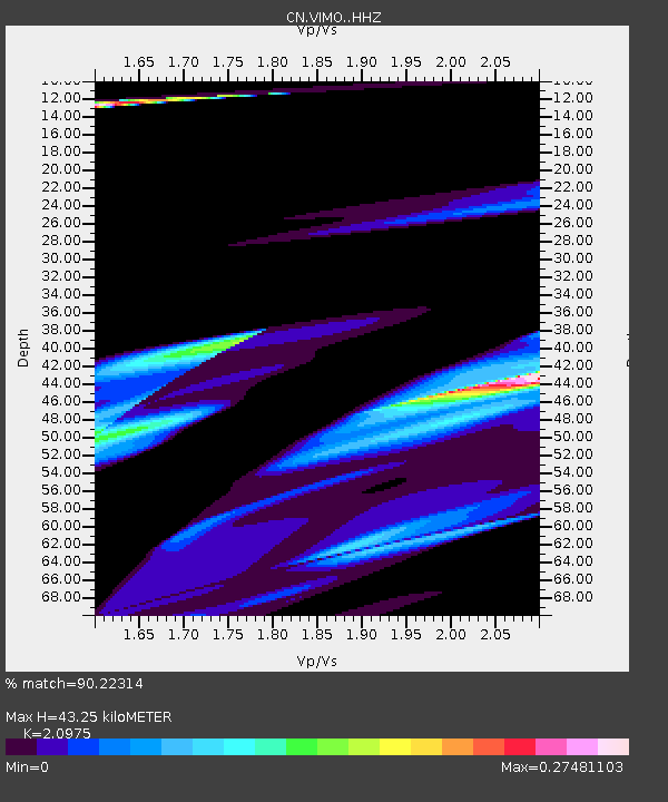
| Estimated Moho Depth: |
43.25 km |
| Estimated Crust Vp/Vs: |
2.10 |
| Assumed Crust Vp: |
6.459 km/s |
| Estimated Crust Vs: |
3.08 km/s |
| Estimated Crust Poisson's Ratio: |
0.35 |
|
| Radial Match: |
90.22314 % |
| Radial Bump: |
400 |
| Transverse Match: |
63.068295 % |
| Transverse Bump: |
141 |
| SOD ConfigId: |
7422571 |
| Insert Time: |
2019-04-20 20:01:30.939 +0000 |
| GWidth: |
2.5 |
| Max Bumps: |
400 |
| Tol: |
0.001 |
|

Signal To Noise
| Channel | StoN | STA | LTA |
| CN:VIMO: :HHZ:20150916T23:40:19.579971Z | 1.6053089 | 1.8449232E-4 | 1.1492637E-4 |
| CN:VIMO: :HHN:20150916T23:40:19.579971Z | 0.42323616 | 3.9442373E-5 | 9.319236E-5 |
| CN:VIMO: :HHE:20150916T23:40:19.579971Z | 1.7805722 | 5.649086E-5 | 3.172624E-5 |
| Arrivals |
| Ps | 7.5 SECOND |
| PpPs | 20 SECOND |
| PsPs/PpSs | 28 SECOND |


