You are here: Home > Network List > TA - USArray Transportable Network (new EarthScope stations) Stations List
> Station A04D Lummi Island, WA, USA > Earthquake Result Viewer
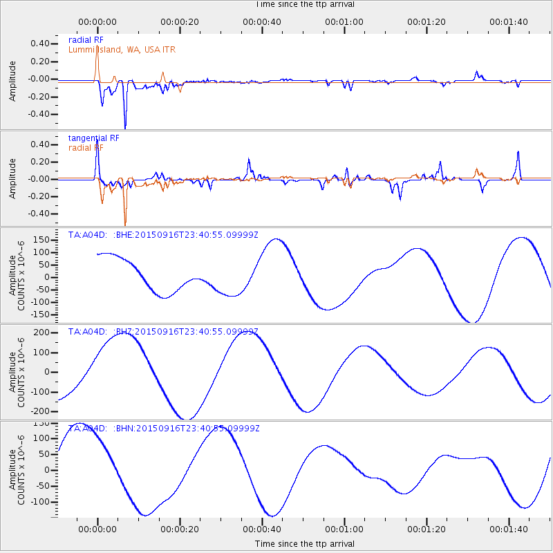
A04D Lummi Island, WA, USA - Earthquake Result Viewer
*The percent match for this event was below the threshold and hence no stack was calculated.
| Earthquake location: |
Near Coast Of Central Chile |
| Earthquake latitude/longitude: |
-30.7/-71.8 |
| Earthquake time(UTC): |
2015/09/16 (259) 23:28:23 GMT |
| Earthquake Depth: |
21 km |
| Earthquake Magnitude: |
5.5 MB |
| Earthquake Catalog/Contributor: |
NEIC PDE/NEIC COMCAT |
|
| Network: |
TA USArray Transportable Network (new EarthScope stations) |
| Station: |
A04D Lummi Island, WA, USA |
| Lat/Lon: |
48.72 N/122.71 W |
| Elevation: |
13 m |
|
| Distance: |
91.2 deg |
| Az: |
329.065 deg |
| Baz: |
138.049 deg |
| Ray Param: |
$rayparam |
*The percent match for this event was below the threshold and hence was not used in the summary stack. |
|
| Radial Match: |
91.90689 % |
| Radial Bump: |
377 |
| Transverse Match: |
51.99983 % |
| Transverse Bump: |
308 |
| SOD ConfigId: |
7422571 |
| Insert Time: |
2019-04-20 20:04:18.567 +0000 |
| GWidth: |
2.5 |
| Max Bumps: |
400 |
| Tol: |
0.001 |
|
Signal To Noise
| Channel | StoN | STA | LTA |
| TA:A04D: :BHZ:20150916T23:40:55.09999Z | 2.2533498 | 1.8597301E-4 | 8.2531806E-5 |
| TA:A04D: :BHN:20150916T23:40:55.09999Z | 1.1252744 | 9.169605E-5 | 8.148772E-5 |
| TA:A04D: :BHE:20150916T23:40:55.09999Z | 1.2002033 | 7.615502E-5 | 6.345177E-5 |
| Arrivals |
| Ps | |
| PpPs | |
| PsPs/PpSs | |


