You are here: Home > Network List > UW - Pacific Northwest Regional Seismic Network Stations List
> Station LCCR Mulino, OR, USA > Earthquake Result Viewer
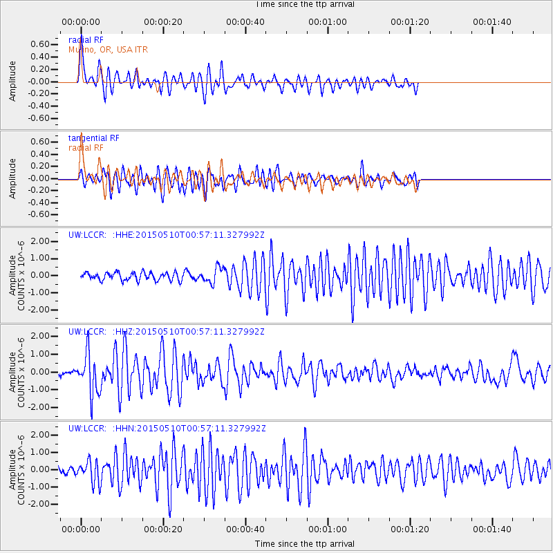
LCCR Mulino, OR, USA - Earthquake Result Viewer
*The percent match for this event was below the threshold and hence no stack was calculated.
| Earthquake location: |
Near Coast Of Chiapas, Mexico |
| Earthquake latitude/longitude: |
14.9/-94.0 |
| Earthquake time(UTC): |
2015/05/10 (130) 00:50:18 GMT |
| Earthquake Depth: |
6.7 km |
| Earthquake Magnitude: |
5.6 MB |
| Earthquake Catalog/Contributor: |
NEIC PDE/NEIC COMCAT |
|
| Network: |
UW Pacific Northwest Regional Seismic Network |
| Station: |
LCCR Mulino, OR, USA |
| Lat/Lon: |
45.21 N/122.48 W |
| Elevation: |
273 m |
|
| Distance: |
38.6 deg |
| Az: |
327.313 deg |
| Baz: |
132.38 deg |
| Ray Param: |
$rayparam |
*The percent match for this event was below the threshold and hence was not used in the summary stack. |
|
| Radial Match: |
79.13797 % |
| Radial Bump: |
400 |
| Transverse Match: |
78.517166 % |
| Transverse Bump: |
400 |
| SOD ConfigId: |
976571 |
| Insert Time: |
2015-05-24 01:38:04.037 +0000 |
| GWidth: |
2.5 |
| Max Bumps: |
400 |
| Tol: |
0.001 |
|
Signal To Noise
| Channel | StoN | STA | LTA |
| UW:LCCR: :HHZ:20150510T00:57:11.327992Z | 8.19436 | 1.1565348E-6 | 1.411379E-7 |
| UW:LCCR: :HHN:20150510T00:57:11.327992Z | 2.9407446 | 6.397283E-7 | 2.1753957E-7 |
| UW:LCCR: :HHE:20150510T00:57:11.327992Z | 2.0351546 | 4.5980397E-7 | 2.2593073E-7 |
| Arrivals |
| Ps | |
| PpPs | |
| PsPs/PpSs | |


