You are here: Home > Network List > IU - Global Seismograph Network (GSN - IRIS/USGS) Stations List
> Station TUC Tucson, Arizona > Earthquake Result Viewer
TUC Tucson, Arizona - Earthquake Result Viewer

| Earthquake location: |
Tonga Islands |
| Earthquake latitude/longitude: |
-16.9/-174.2 |
| Earthquake time(UTC): |
2000/01/08 (008) 16:47:20 GMT |
| Earthquake Depth: |
183 km |
| Earthquake Magnitude: |
6.5 MB, 6.6 MS, 7.2 MW, 7.0 ME |
| Earthquake Catalog/Contributor: |
WHDF/NEIC |
|
| Network: |
IU Global Seismograph Network (GSN - IRIS/USGS) |
| Station: |
TUC Tucson, Arizona |
| Lat/Lon: |
32.31 N/110.78 W |
| Elevation: |
874 m |
|
| Distance: |
78.0 deg |
| Az: |
50.765 deg |
| Baz: |
241.113 deg |
| Ray Param: |
0.049490593 |
| Estimated Moho Depth: |
53.75 km |
| Estimated Crust Vp/Vs: |
1.72 |
| Assumed Crust Vp: |
6.276 km/s |
| Estimated Crust Vs: |
3.649 km/s |
| Estimated Crust Poisson's Ratio: |
0.24 |
|
| Radial Match: |
98.07704 % |
| Radial Bump: |
240 |
| Transverse Match: |
89.54224 % |
| Transverse Bump: |
400 |
| SOD ConfigId: |
3744 |
| Insert Time: |
2010-03-04 19:47:30.057 +0000 |
| GWidth: |
2.5 |
| Max Bumps: |
400 |
| Tol: |
0.001 |
|
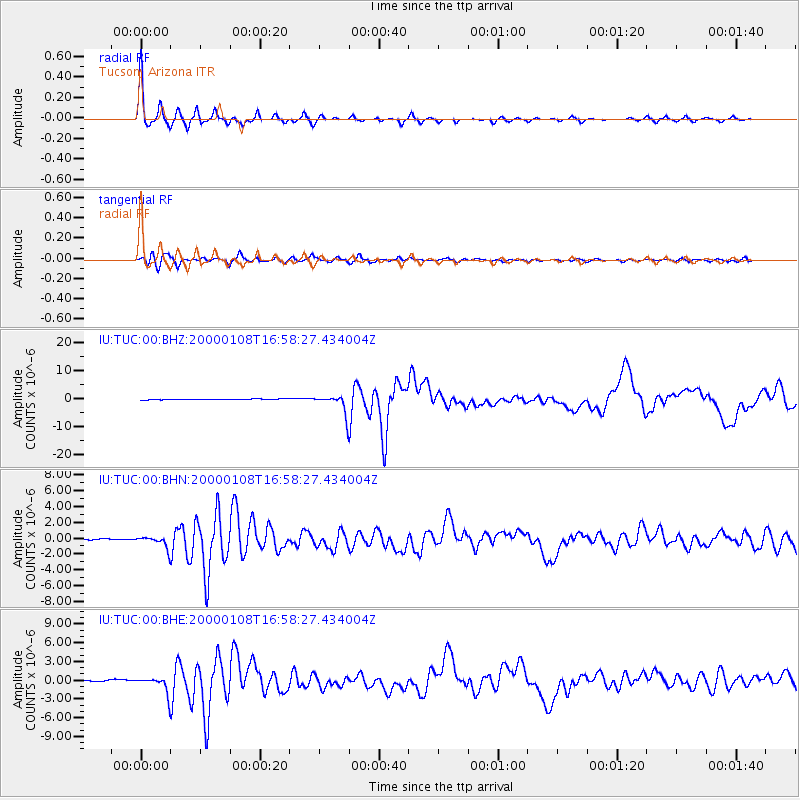
Signal To Noise
| Channel | StoN | STA | LTA |
| IU:TUC:00:BHN:20000108T16:58:27.434004Z | 8.982004 | 7.7891934E-7 | 8.671999E-8 |
| IU:TUC:00:BHE:20000108T16:58:27.434004Z | 9.588228 | 1.3880175E-6 | 1.4476267E-7 |
| IU:TUC:00:BHZ:20000108T16:58:27.434004Z | 23.584219 | 3.388621E-6 | 1.4368172E-7 |
| Arrivals |
| Ps | 6.3 SECOND |
| PpPs | 23 SECOND |
| PsPs/PpSs | 29 SECOND |


