You are here: Home > Network List > CI - Caltech Regional Seismic Network Stations List
> Station GSC Goldstone, California, USA > Earthquake Result Viewer
GSC Goldstone, California, USA - Earthquake Result Viewer
| Earthquake location: |
South Of Fiji Islands |
| Earthquake latitude/longitude: |
-22.1/-176.8 |
| Earthquake time(UTC): |
1997/10/14 (287) 09:53:18 GMT |
| Earthquake Depth: |
167 km |
| Earthquake Magnitude: |
6.7 MB, 7.7 UNKNOWN, 7.4 ME |
| Earthquake Catalog/Contributor: |
WHDF/NEIC |
|
| Network: |
CI Caltech Regional Seismic Network |
| Station: |
GSC Goldstone, California, USA |
| Lat/Lon: |
35.30 N/116.81 W |
| Elevation: |
954 m |
|
| Distance: |
80.5 deg |
| Az: |
45.881 deg |
| Baz: |
234.485 deg |
| Ray Param: |
0.047810934 |
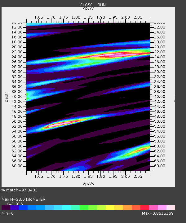
| Estimated Moho Depth: |
23.0 km |
| Estimated Crust Vp/Vs: |
1.91 |
| Assumed Crust Vp: |
6.276 km/s |
| Estimated Crust Vs: |
3.277 km/s |
| Estimated Crust Poisson's Ratio: |
0.31 |
|
| Radial Match: |
97.0483 % |
| Radial Bump: |
400 |
| Transverse Match: |
92.61256 % |
| Transverse Bump: |
400 |
| SOD ConfigId: |
4770 |
| Insert Time: |
2010-02-25 23:45:02.980 +0000 |
| GWidth: |
2.5 |
| Max Bumps: |
400 |
| Tol: |
0.001 |
|
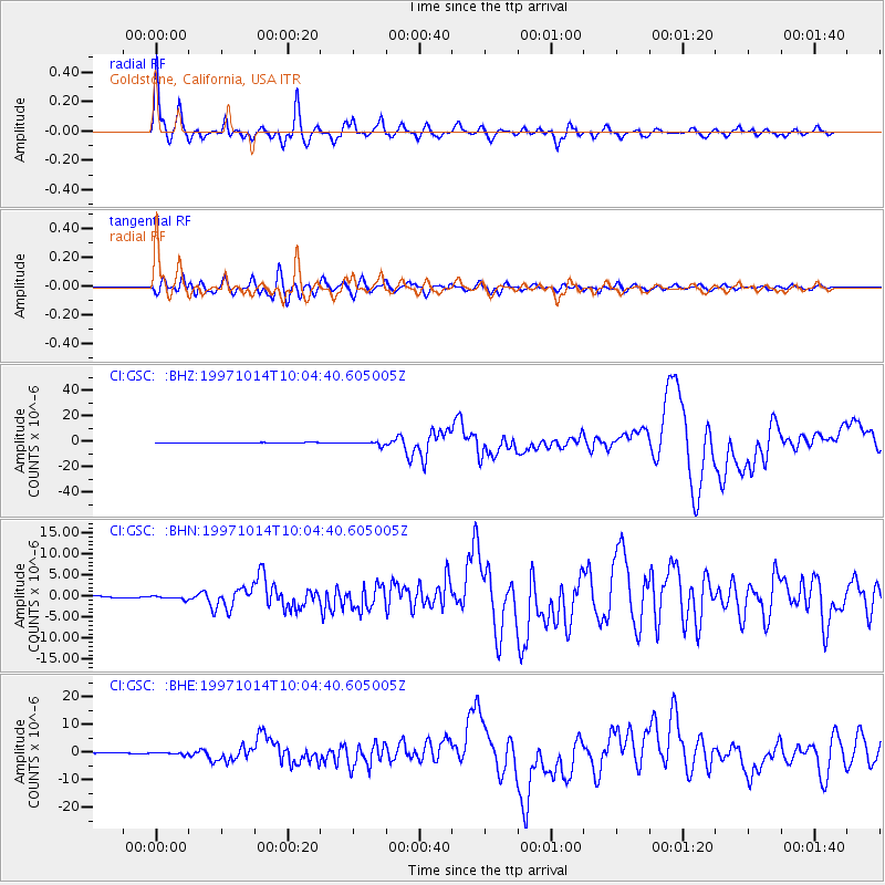
Signal To Noise
| Channel | StoN | STA | LTA |
| CI:GSC: :BHN:19971014T10:04:40.605005Z | 1.5631267 | 3.7089882E-7 | 2.3728008E-7 |
| CI:GSC: :BHE:19971014T10:04:40.605005Z | 2.8946617 | 4.2010123E-7 | 1.4512965E-7 |
| CI:GSC: :BHZ:19971014T10:04:40.605005Z | 8.290423 | 1.4254874E-6 | 1.7194385E-7 |
| Arrivals |
| Ps | 3.4 SECOND |
| PpPs | 10 SECOND |
| PsPs/PpSs | 14 SECOND |


